Thunderstorms set to break our long stretch of tranquil summer weather in Seattle
 Scott Sistek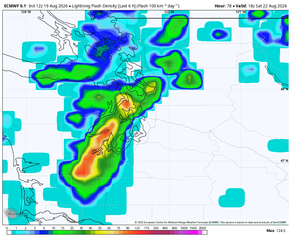
ECMWF 6 hour accumulated lightning forecast for Saturday morning.
Even as a rain fan, I have to admit: It’s been a pretty pleasant week of summer weather around Seattle and Western Washington, with the last *10* days featuring high temperatures in Seattle between 74 and 81.
But the bill is coming due, in the form of not only some possible rain on a summer weekend, but maybe some thunderstorms too. It may be a nuisance for Western Washington, but may be dangerous again for Eastern Washington. (More on the Eastern WA risk later — or you can skip ahead – I put a big note where that forecast begins…)
After some waffling through the week, forecast models are now more confident that an upper level low pressure center currently swirling out in the Pacific is going to head our way for the weekend.
Thursday will keep the status quo of sunshine and near 80 degrees, and Friday will also stay dry just with perhaps some increasing clouds — a sign of the changes afoot. (Friday might actually warm a little bit more into the low-mid 80s if that low draws some warmer air ahead of it.)
The low is currently pegged to start moving ashore in southwestern Washington overnight Friday night.
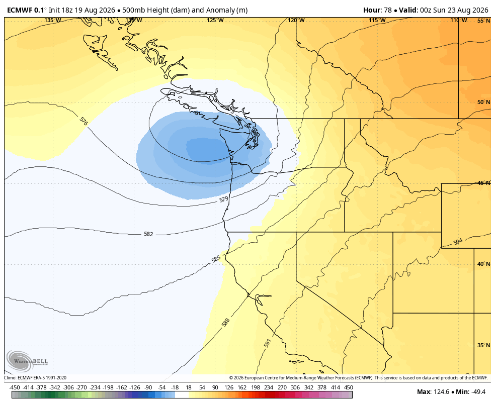
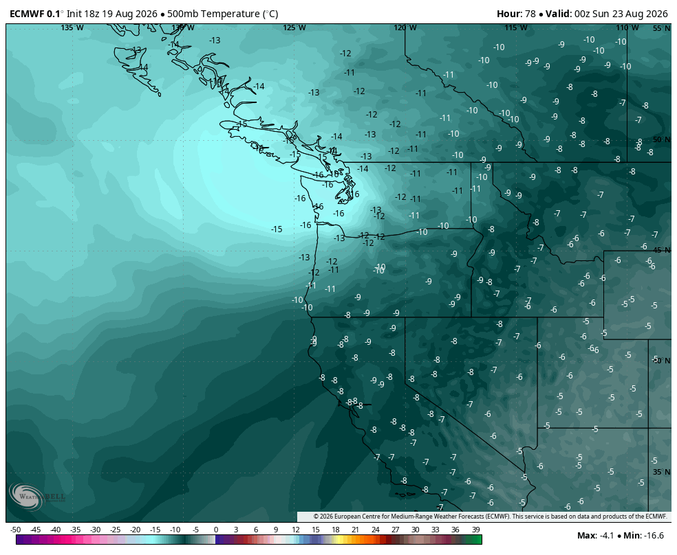
And with the low’s mix of cool air aloft generating atmospheric instability, lingering warmth from the days before, and a moderate slug of atmospheric moisture, it will provide fuel for scattered thunderstorms.
The most recent timing has showers and thunderstorms first starting along the southwestern Washington coast around midnight, then slowly spreading north/northeast up into the Olympic Peninsula, Kitsap Peninsula and, yes, potentially the I-5 corridor through the Seattle/Puget Sound region by around dawn Saturday morning or a little later. The North Sound and Northwest Interior would then start to get their rumbles of thunder an hour or two later.
The rest of Saturday morning would feature scattered showers and thunderstorms — some with sudden downpours — with storms tapering off from southwest to northeast as the low moves into B.C. later in the day. However, there is a chance of lingering rain showers Saturday afternoon through Sunday morning. (Any rain Seattle gets will be the first of August! :O )
WHAT’S STILL UNCERTAIN?
While the overall pattern is coming into better focus, there is still a decent amount of uncertainty in the timing — some models push the storms a little later into Saturday arrival — and how far east the storms go in Western Washington.
Right now all areas in Western WA have a chance of lightning, but the better chances appear to be west of Puget Sound (Olympic/Kitsap Peninsula) and the North Sound/Northwest Interior later in the event.
ARE THESE THUNDERSTORMS LOOKING SEVERE OR NOTEWORTHY?
Right now, not really. We’re looking more the isolated-to-scattered pop-up variety — no like big squall line of storms or “big blob” of storms. I doubt NOAA’s Storm Prediction Center will pay us much attention. We shouldn’t get a convergence zone either.
Now, if you get under one of these storms it could briefly rain very heavily with gusty winds and maybe even some hail. But not everyone will get hit.
(And of course, any lightning is dangerous — even one strike! I know it’s one of the waning weekends of summer but need to be eagle eye to the weather, especially if you’re up in the mountains.)
It will also be noticeably cooler with highs in the 60s to low 70s Saturday. We’ll rebound with a few degrees warming on Sunday, then next Monday and Tuesday look like we return to the current pattern of upper 70s and sunshine.
However, there are hints we may again deal with another round of showers in the middle of the week.
(If you’re only interested in Western Washington weather, you can stop here, because now it’s time for…)
HEY CENTRAL AND EASTERN WASHINGTON FOLKS, HERE’S YOUR FORECAST!
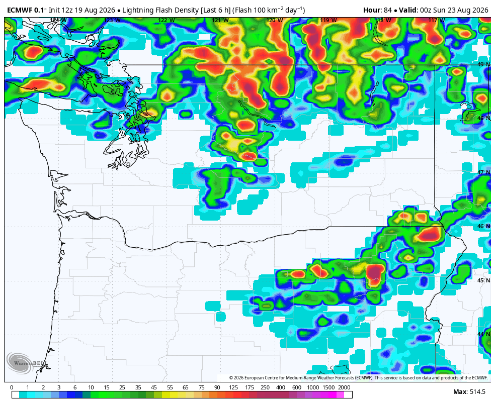
Unfortunately for Central and Eastern Washington, low pressure centers mean the return of thunderstorms… and wind. Both are bad for current fires and any new ones started by fresh lightning.
Thunderstorms will begin to develop around midday Saturday and last into Saturday evening. It appears much like the last few times, the bulk of the lightning will stay in the northern half of Eastern Washington.
On the other hand, the Columbia Basin will be where the strongest winds are expected – about 30-40 mph gusts. But even the rest of Eastern Washington are expecting gusts of 25 mph.
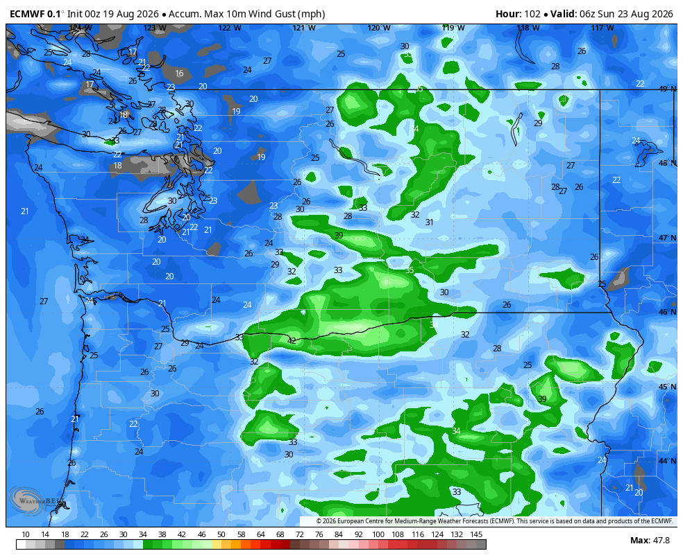
Some of these thunderstorms may end up rather dry for rain, especially in the early stages, but storms should get wetter as the day moves on. In fact, the NWS warns that some storms could go too far and bring heavy downpours to burn scar areas that could trigger flash flooding.
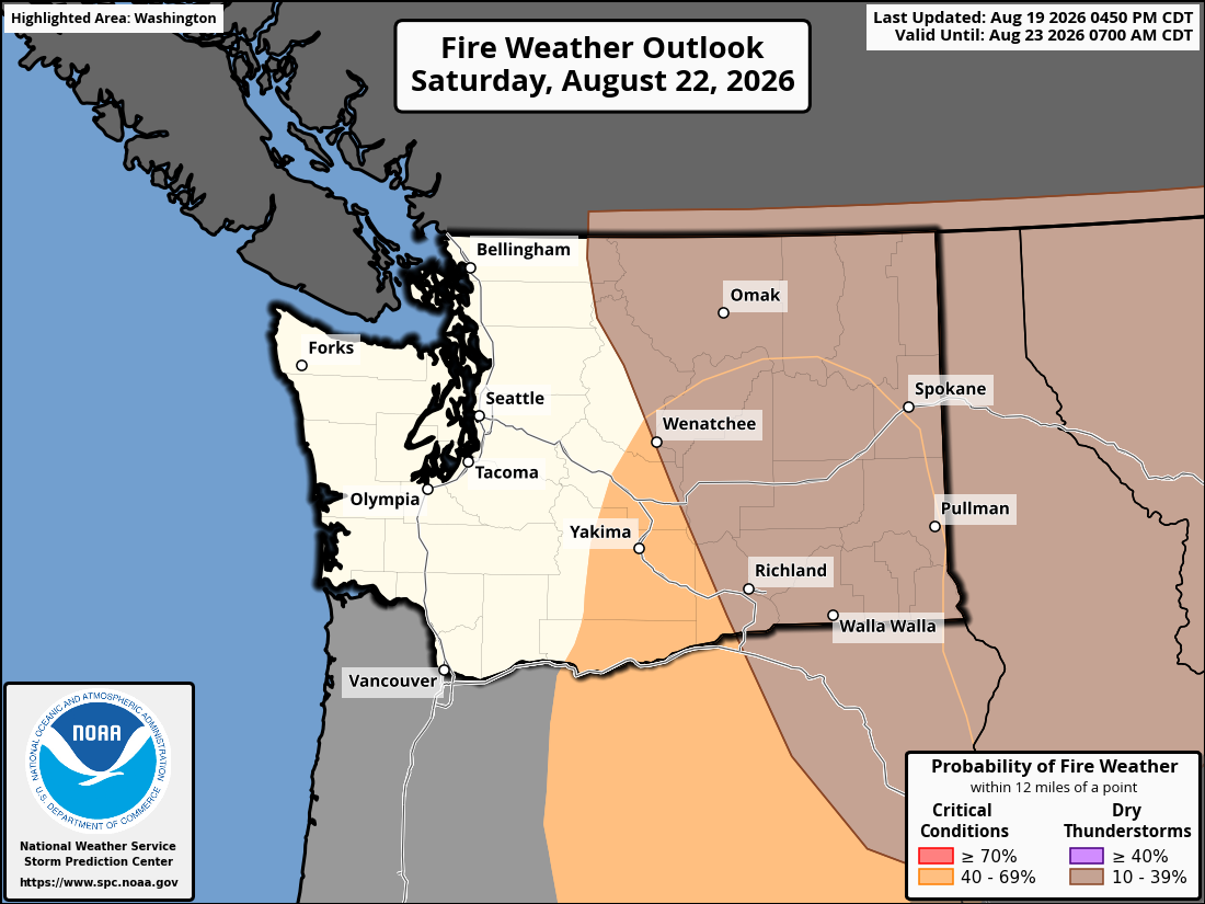
The winds could also bring blowing dust and make travel difficult both for visibility and with high profile vehicles.
So to chalk it up: Saturday east of the mountains will be hot and windy with scattered thunderstorms and possible dust. Storms will taper off Saturday night and Sunday’s lone saving grace will be it will be much cooler over there back into the 80s.
But it’s short lived as heat returns Monday-Wednesday, then perhaps *another* round of thunderstorms mid week. 😐
I MADE IT THIS FAR AND I FEEL LIKE I NEED MORE SOLACE AUTUMN IS COMING…
OK, how about this: I wrote here a week or so ago about how Seattle’s average high temperate began falling on August 10th. Did you know that Tuesday’s record high of 88 in Seattle was the first record high of under 90 degrees since the summer solstice on June 21? (Hat tip: Dana Felton with NWS Seattle).
Felton also noted that only 15 of Seattle’s 91 days of 90+ in August have come after August 18th. And he says if you count the entire year, only 12% of Seattle’s 90+ days have come after August 18 (though half of that tally have come in the past 10 years.)
(Can you tell I’m excited for fall?)
MORE TO EXPLORE:
- What are some scenarios a historic ‘Super El Nino’ could present for the Pacific Northwest and California?
- How ensemble models can help solve the mystery of will it rain this weekend in Seattle?
- Here is how to find and read wildfire smoke forecast models for Seattle and the U.S.