Could Tuesday be Seattle’s last ‘hot’ day of this summer? (And here comes the smoke again)
 Scott Sistek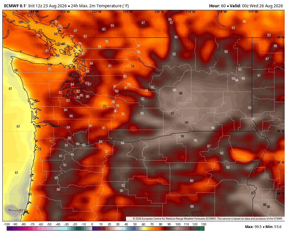
ECMWF predicted high temperatures for Tuesday in Washington.
This post today is either going to make the autumn fans rejoice…or end up being the ultimate jinx, but dare I declare that Tuesday is looking like the last “hot” day of our summer?
I sometimes picture the summer dry season like when as kids we’d play like soccer or baseball on our residential street and someone yells “CAR!” when one approached, and we’d all briefly clear the way before resuming.
Summer’s weather cadence is like that here akin to a rural street, with only rare occasions needing a brief pause for “CAR!” as a storm passes through, and we resume our summer sunshine games. (For example, Sea-Tac Airport STILL doesn’t have any measurable rain this August.)
Currently, the last remnants of the upper level low pressure system that somewhat underperformed in Western Washington for thunderstorms (though certainly not zero), but made up for it by bringing a historic thunderstorm outbreak across Vancouver Island and the Vancouver, B.C. area Saturday night, (with 6+ hours of lightning at Vancouver’s airport!) is ”driving off into the distance”, and summer sunshine is on its way back.
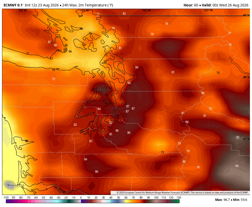
How back? Monday is looking “sunny” and upper 70s as winds veer north instead of onshore, while winds turn a bit offshore Tuesday and we get hot — to about 85 degrees in Seattle*+**
WOW! TWO ASTERISKS?!?
*- As a longtime Seattleite, I’ve learned in my local weather forecasting career that 84 degrees seems to be about the point where “tolerable summer warmth” becomes “it’s too hot” for most Seattle folks. Yes, not ALL, but many (and I mean Seattle, not Los Angeles or Miami, etc…). So a high of 85, I say qualifies as “hot”. Agree or disagree below… 😉
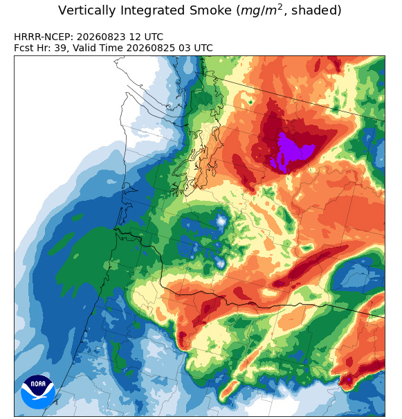
**- But lest we forget already what happens when we turn the winds around from a not-west direction this summer? Wildfire smoke returns. The forecast models are indeed showing a return of smoke from B.C. on Monday and Tuesday. Similar to last week, it looks like it’ll make it hazy but not orangemageddon with most smoke remaining aloft.
However, areas along the Cascade foothills may see some surface smoke move in from Eastern Washington and Canada’s Fraser River Valleys late Monday into Tuesday, making for possibly poor air quality over there. The smoky haze could keep temperatures a couple degrees cooler than the day would otherwise reach under clear sunny skies.
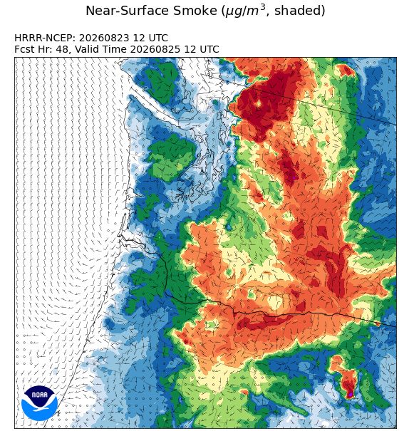
(Central Washington may again also see air quality significantly degrade for the mid-week as that smoke in Eastern Washington gets pushed back up against the eastern Cascade foothills 🙁 )
Still, sun fans, if the air quality is OK, absorb that heat. Because…
IT’S GOING TO GET… TROUGHY?
The models show that this “hot day” is just “one day”, with a weak trough (“CAR!”) moving through on Wednesday and Thursday. The main effects will be to flip the winds back to the west and rev them up a bit, dually scouring out the heat and smoke while pushing in cloudier, cooler weather. There is a risk of some passing light showers or sprinkles, mainly north of Seattle at this point, but not much of even a wetting rain.
That “car” passes and we resume a dry and pleasant end to the week, but with onshore flow remaining and highs in the 70s.
The long range forecasts have been showing at least a signal for a stronger system (Ummm… “SUV!?!”) with more widespread rain and cooler temperatures sometime around the end of next weekend or into the first week of September. There is no general consensus yet on when/where/how much rain, but instead it’s like: It just doesn’t look hot after Tuesday for the next several days.
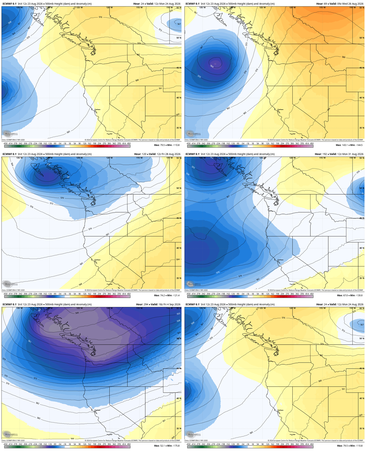
Does this mean summer and/or warm days are canceled? No. We can certainly get very warm — yes, even “hot” — days in September. A few years ago we hit the mid 80s on a day in October.
But if ridges of high pressure dominate with sunshine and troughs of low pressure dominate with clouds and showers: Summer has more ridgey than troughy, but now the long range outlooks for the next few weeks are more troughey than ridgey. Doesn’t necessarily mean it’ll start being wet all the time or that fall is starting early, but does suggest more strong onshore flow days with clouds around for a bulk of the day’s hours and… not “hot” temps. I think we can all take that.
Eventually though, the troughs will win out, turning our slow residential street into a bustling freeway of constant “traffic” and we all just pick up and go home, never to venture outside again until May 😂
OLIVE BRANCH FOR SUN FANS: 😎
For the sun fans who have read this far, a little bonus treat from Dana Felton with the Seattle office of the National Weather Service.
“With a high of 76, Saturday was the 37th day in a row with a high 70 degrees plus in Seattle,” Felton said. “This is now the 10th longest streak of its kind.”
The record was set just 9 years ago, from June 29-Sept. 8 in 2017. I’d say we have zero chance of reaching that level this year, but then again with zany El Niño on the way, I’m loathe to declare anything impossible this year.
We’re also working on this being the 6th August in Seattle when every high temperature was above 70 (2022, 2017, 2012, 2003 and 1967.)
On the flip side, as I mentioned earlier, Sea-Tac Airport has yet to have measurable rainfall this August. The current “Trace” would tie 2012 for driest August on record.
And finally, one of what Felton calls is favorite August weather stats for Seattle: The last time Seattle set a record low temperature in August was August 8, 1974 (48 degrees).
MORE TO EXPLORE:
- Sunset and severe thunderstorms spawn spectacular sights Saturday over Vancouver Island
- What are some scenarios a historic ‘Super El Nino’ could present for the Pacific Northwest and California?
- How ensemble models can help solve the mystery of will it rain this weekend in Seattle?
- Winter is coming: Seattle’s normal high temperatures begin their descent toward January