That time Punxsutawney Phil saw his shadow and Seattle ended up with a record blizzard
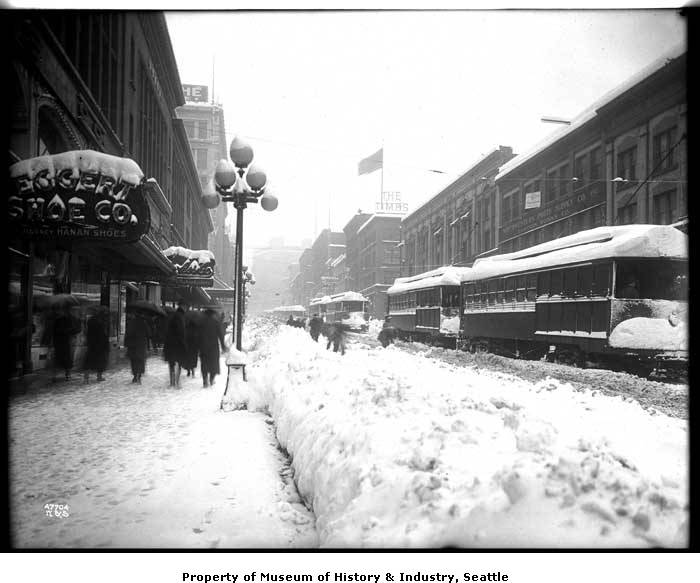
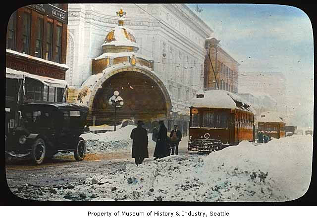
Snow scene on Second Avenue, February 2, 1916 (Photo: Webster& Stevens / Seattle Museum of History & Industry)
110 years ago, Punxsutawney Phil emerged from his lair and saw his shadow, proclaiming 6 more weeks of winter…
To which Seattle cried out in unison: “WE’RE WAY AHEAD OF YOU!”
Because while the 2-5 feet of the “Storm King” snow of January 1880 might be the greatest unofficial snow in Seattle history, and the 20” that would fall at Sea-Tac Airport on Jan. 13, 1950 is the current snowiest day at Seattle’s current official record station, the Groundhog Day Blizzard of Feb. 2, 1916 holds the distinction of the greatest snow Seattle has ever officially measured.
A whopping 21.5 inches fell that day at the official site (back then) in Downtown Seattle, wreaking all sorts of havoc, ruining what was a nice ice skating party at Green Lake, and wiping out one of Seattle’s larger cathedrals.
It then also proved shortly there after that Phil has NO idea what he’s talking about when spring roared in like a lion days later.*
(*-YES, I know that’s a March idiom, not February… Just go with the calendar was broken that year. )
1916 had been a cold start to the year already, though not epically cold. But there were still enough days in the 20s and 30s to amass 23 inches of total snow as the calendar neared the end of the month.
Jan. 23 had a high of 51 but eventually 2.5” of snow as an arctic front swept through, ushering in several days of freezing weather that managed to turn much of Green Lake into a decent sheet of ice, according to local historian Paul Dorpat.
He said about 3,000 people flocked to Green Lake on Sunday, Jan. 30 as part of a “day of rest” even that went well into the evening with bonfires on the shores and a grand old time. It started snowing on Monday — just a light snow at first, but eventually got heavier with about 3.5 inches by that evening.
Dorpat said it was enough snow to kill the skating.
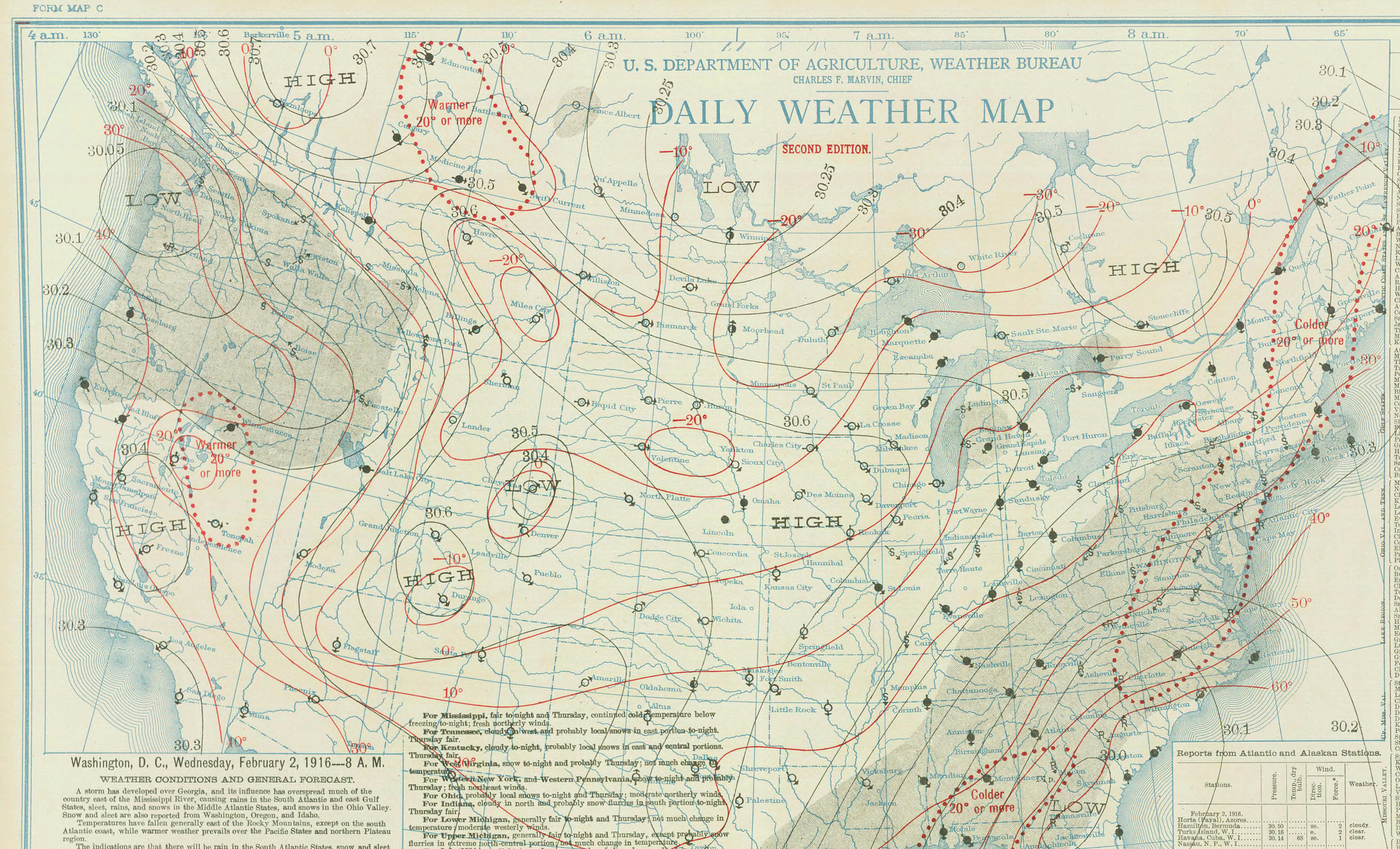
But as this historical weather map shows, a large arctic high was entrenched in B.C. and a big storm came into southwestern Washington — THE perfect setup to put a large batch of moisture on top of a cold air mass.
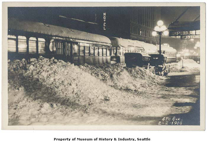
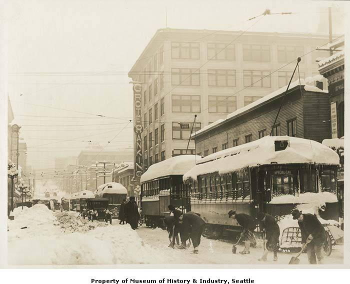
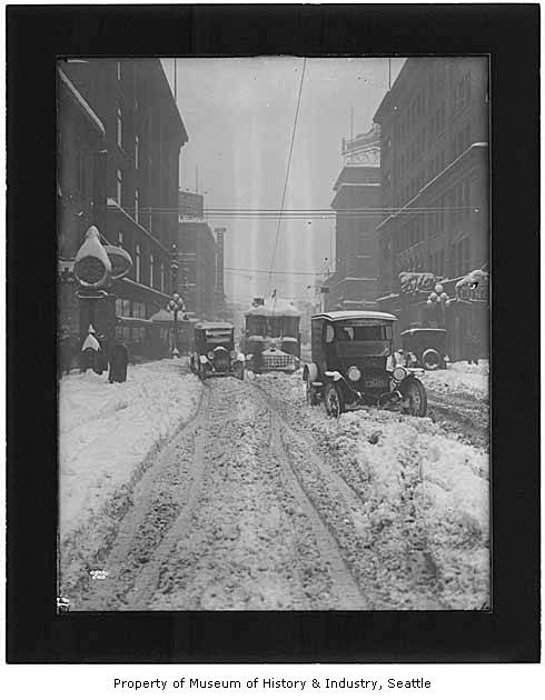
But the brunt of the winter storm came in as a blizzard on the evening of Tuesday, Feb. 1 just as the 1916 version of Seattle’s “evening commute” was getting under way. The snow and wind were relentless and by the time night fell again on Feb. 2, some 28.5 inches of new snow was recorded — 7 inches on Feb. 1 and 21.5 inches on Feb. 2.
Dorpat said snowplows (WHAT? SEATTLE HAD SNOW PLOWS BACK THEN? What…changed their mind today?) had trouble keeping streetcar tracks clear because passing cars would push the snow right back on the tracks.
MORE: SEE MORE PHOTOS OF 1916 BLIZZARD FROM UW PHOTO COLLECTIONS
But once all the slush froze, it created frozen snowballs that caused “the absolute ruination of tires and tempers,” according to Seattle’s MOHAI, quoting the Seattle Times.
While many buildings suffered damage from the intense weight of the snow, the most notable damage in the city came from the collapse of the 15-ton great dome atop St. James Cathedral.
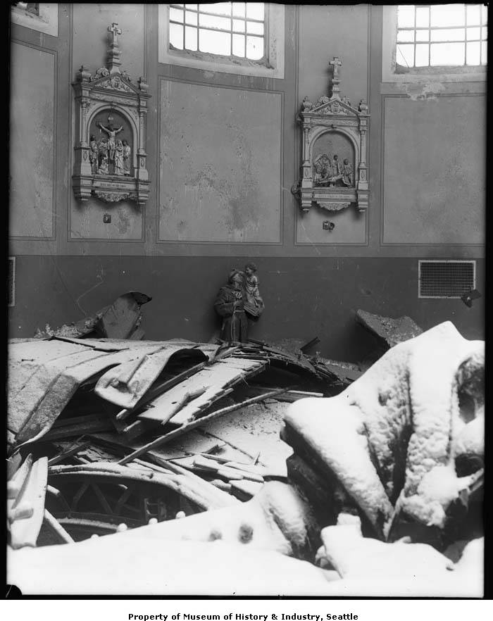
It might have been divine intervention that no one was inside at the time, so there were no injuries, but MOHAI’s account says the force of the collapse blew out the windows and shoved all the pews by the front entrance, while leaving a 50-foot-wide hole in the roof. It took more than a year to rebuild.
WAIT, THE GROUNDHOG WAS WRONG? :O
So, what’s worse than dropping 3 feet of snow in Seattle in a few days? OOOH I see some of you here 20 years ago in late December of 1996 might be raising your hand.
How about dropping 3 feet of snow, then dump some warm torrential rains on top of it?
No one knew what an “atmospheric river” was back then, but they were about to see what happens when you mix one with a blizzard. By Feb. 7, the temperature warmed to 46 degrees with 1.01 inches of rain. More heavy rain, totaling about 3 inches, fell over the next few days with temperatures back up to around 50.
It’s Slushmaggedon! Seattle went from 18 inches of snow base on Feb. 6 to 3 inches on Feb. 10. (Skiers are like: Can we raise our hand for this year too?)
The heavy rains triggered several mudslides around Queen Anne, West Seattle and Magnolia, Dorpat said. But with the rains, came some sort of Seattle normalcy. Snow-bound trains shook free and arrived in Seattle. And Streetcar service returned to normal.
By Valentine’s Day the high in Seattle was (checks notes): 58 degrees! It hit 58 again on the 15th. It’d stay in the 50s, reaching 59 on the 18th (!) and again a 2-day stretch of 58 and 59 degrees on Feb 26-27 — WHAT BLIZZARD?!?!
It snowed again on March 2.
I don’t know, Scott – January 1916 was Seattle’s 2nd coldest month on record with a mean monthly temperature of 30.9F. Only January 1950 was colder (mean monthly temperature 28.7F). It also featured Seattle’s 2nd greatest number of recorded freezing daily minimum temperatures during any calendar month (25) behind only January 1949 (26) and the 2nd greatest number of recorded freezing daily maximum temperatures during any calendar month (12) behind January 1950 (17). I’d say that’s pretty epically cold by Seattle standards! Also, January 1916 was Seattle’s 2nd snowiest January on record, with 23.3″ (behind January 1950, with 31″) and February 1916 was Seattle’s snowiest February (as well as snowiest calendar month) on record, with 35.4″. The 58.7″ total snowfall was by far the snowiest 2 consecutive calendar month period on record for Seattle! Truly epic!
Up in northern Whatcom County, that period was at least as brutal. While it wasn’t as wet and snowy as Seattle, it was terribly cold. At Clearbrook (records began March 1903), the mean monthly temperature for January was 22.7F (also the 2nd coldest month on record after January 1950). On January 25, the daily maximum temperature was 16F, the daily minimum temperature was 11F, and there was 8″ of snowfall. Imagine that amount of snow falling at such cold temperatures; imagine the drifts! The temperature failed to rise above freezing for 18 consecutive days from January 23 through February 9 – the longest sub-freezing period on record for any location in the lowlands of Western Washington!
The big warmup in Seattle never materialized up there, and on February 7, 1.4″ of precipitation was recorded, with a daily maximum temperature of 29F and a daily minimum temperature of 20F. Zero snowfall was recorded that day, so I’m left to presume that it must have been some sort of horrifying freezing rain-mageddon. The next day, 5″ of snowfall was recorded with a daily maximum temperature of 28F and a daily minimum temperature of 21F. I can only imagine that photographs of the area from that period would appear to have been taken in the godforsaken frozen wastes of the High Arctic.