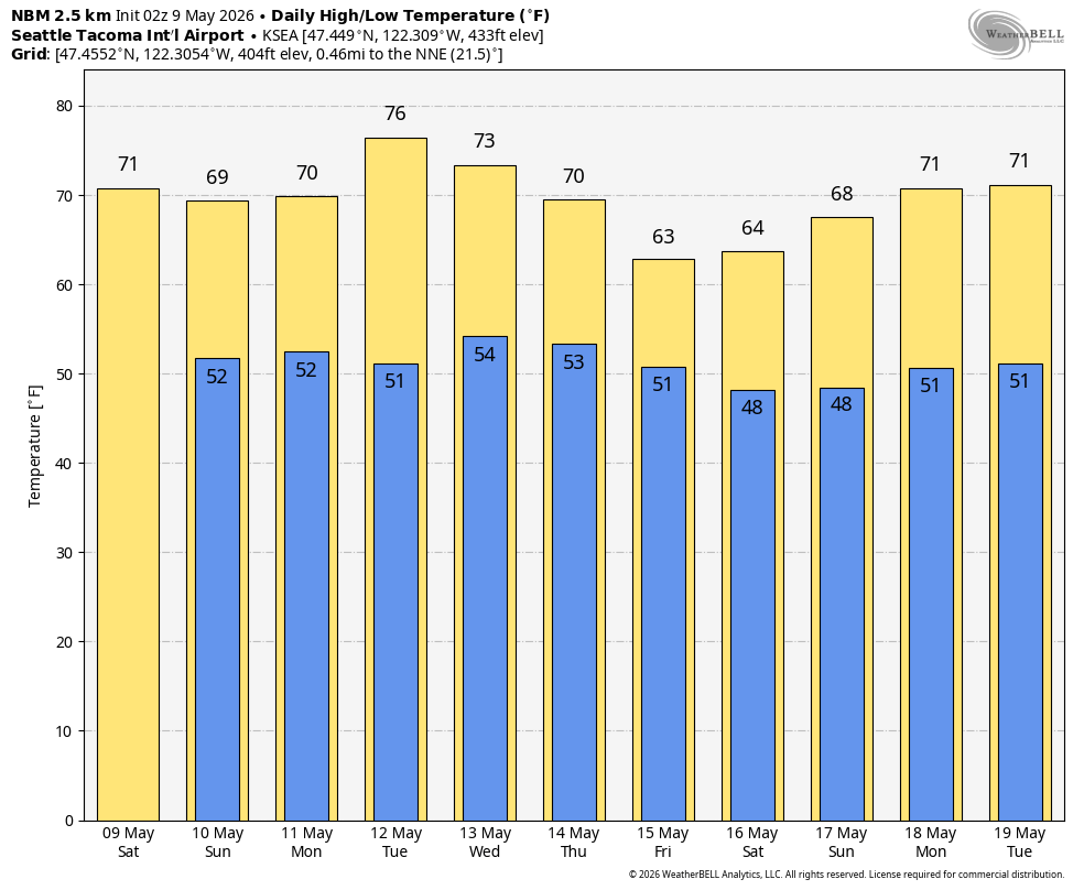
NOAA's blend of forecast models showing predicted high temps for Seattle over the next 10 days.
If you were to ask most people what would you consider their “Goldilocks” weather of it being not to hot, not to cold, but juuuust right, I think the vast majority would say around 68-75 degrees(*).
(*- Some Seatteites excluded. I see all you rain fans!)
But Goldilocks weather, like its namesake character, is usually loathe to stay around for too long. In the famous story, she’s bouncing around from the woods to a cabin to a kitchen, living room, bedroom and then back off into the woods.
In weather, it seems we usually can manage a day or two of low-mid 70s — MAYBE — a third day before Mother Nature becomes like the bear family coming home and finding too pleasant weather in its roost and scares it off, leaving us either back to being too hot or too cold as low 70s sprints off screaming off into the forest… or, maybe Los Angeles.
But not this week! Goldilocks is comfortably snoozing away in the comfy Air BnB cabin in the foothills, the bears are out of town, and I’m working on what might be strangest metaphorical forecast I’ve tried to craft in years.
Anyway, all this to say the weather is going to be pretty darn nice for the next several days, with not one, not two, not three, not four, but FIVE days in a row of highs in the upper 60s to mid 70s range in Seattle — and maybe even a sixth day tacked on at the end of Goldilocks uses her option to extend a day though that is now looking a bit more tenuous. Maybe she’s getting homesick?
We’ve got a very nice balance of onshore flow providing a moderate amount of natural air conditioning to keep temperatures right in the sweet spot over the next several days. While we will get plenty of sunny periods, it won’t be blazing sunshine all the time — we will see varying amounts of morning clouds with the marine layer and perhaps a bit of overcast skies Saturday into midday Sunday as a weak systems slides by to the north in B.C.
But really, a very nice and pleasant stretch of weather coming up through the middle of next week.
WHAT IF I’M MORE LIKE MAMA BEAR AND THIS WEATHER IS TOOOOO HOT?
Hello fellow native Seattleite!
Well, good news for the rain and cool weather fans: Long range models are starting to suggest we may see some cooler weather with even some showers returning to the forecast toward the middle and end of next week as a cut-off low pressure center out in the Pacific Ocean wanders our way.
The forecast models are still quite variable on their outcomes but the ensemble models, which run dozens of versions of the models with minor tweaks in the calculations to get a sense of consistency, are starting to lean more and more on the wetter side.
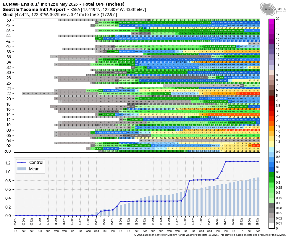
It’s not looking super wet, but at least enough to end the current dry streak which stands at 10 days through Friday.
WHAT IF I’M MORE LIKE PAPA BEAR AND THIS WEATHER IS TOOOOOO COLD?
Well, good news for the sun and heat fans: Summer is still ahead. So I’m sure it won’t be super long before we start talking 80s again.
I’ll write more soon about this “Super El Niño” that’s looking more and more likely but the short version is: you may have plenty of “bonus” warm days for quite some time so hang in there!
In the meantime, let’s let sleeping Goldilocks lie and enjoy the juuuuuuuust right temps!