Seattle active forecast for the next 2 weeks features snow, rain, wind, and even some lightning
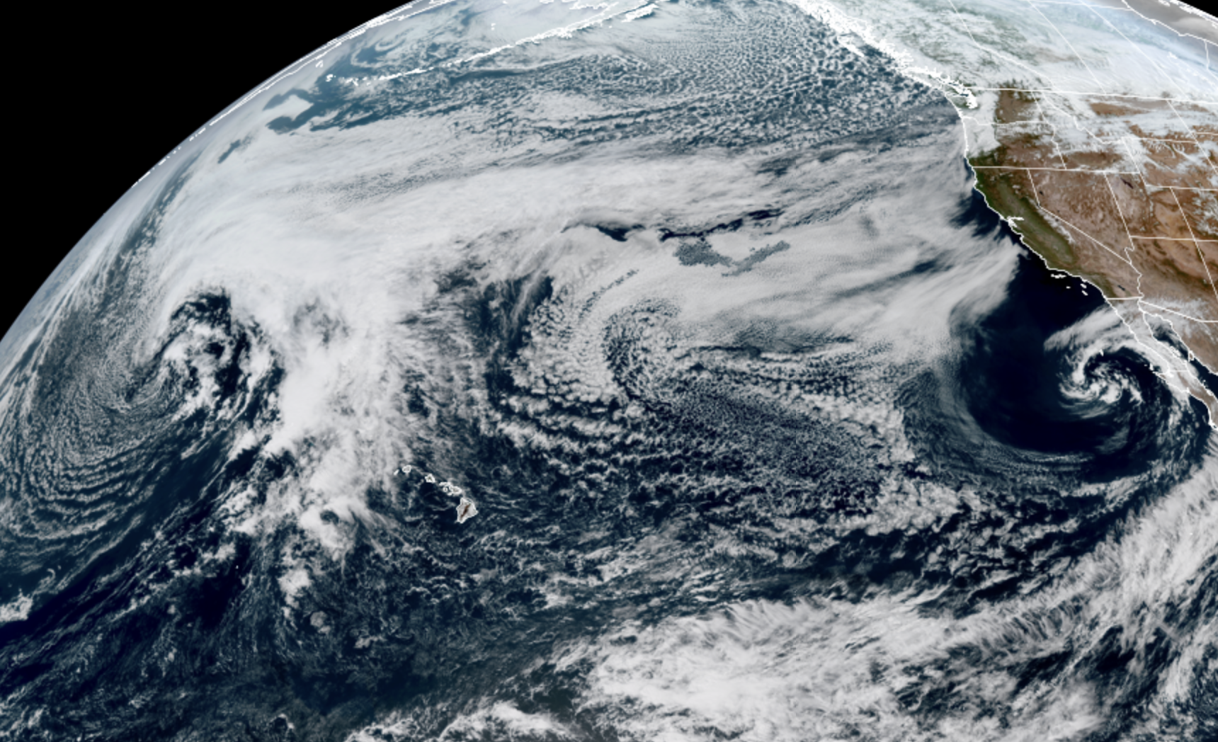
GOES-18 satellite image from Sunday March 8 (NOAA / CIRA / RAAM-B)
The March lion was fashionably late, but now that it’s here, I don’t think the lamb is coming in for relief anytime soon. (Especially if the lamb stops to read this entire forecast first…)
For the TL; DR folks: We have a very active two weeks of weather in three phases:
* First up: Fringey lowland snow (Monday/Tuesday morning). Minor to no impact.
* Second: Several feet of mountain snow (All week but especially Wed/Thursday): High impact to mountain travel/ avalanche danger.
* Third: Maybe strong atmospheric river/flooding event(s?) (Next week): Possible significant impacts to river basins if some of the more wetter forecasts pan out.
(End TL;DR. Thanks for reading!)
For those who want all the deets, I’ll pause here while you go grab a fresh coffee or beverage of choice to get through this all. Hint: Make it a venti.
The local NWS Seattle folks have put together a great media partner briefing on all three and I’ve shared many of the slides here in the post plus added in some of my own.
FIRST UP: FRINGEY LOWLAND SNOW(!)
First of all, to those of you winter weather fans who read my Saturday post, YOU ARE STILL NOT ALLOWED TO GET YOUR HOPES UP! I HAVE MY EYES ON YOU. YES, YOU!
Anyway, cooler air is filtering in behind the storm that came through Sunday morning. Snow levels will drop to around 500 feet or so by dawn which means any scattered showers could be a rain/snow mix or even a brief period of wet snow. Since it’s been warm, it’s not likely going to stick to much of anything — maybe some grassy surfaces.
But as soon as the snow stops, temps will rebound a little and it’ll start to melt. Exception are the higher foothill areas along US 2 (Monroe, Index, Skykomish) which may get a few inches of convergence zone-fueled snow overnight Sunday into Monday and again early Tuesday.
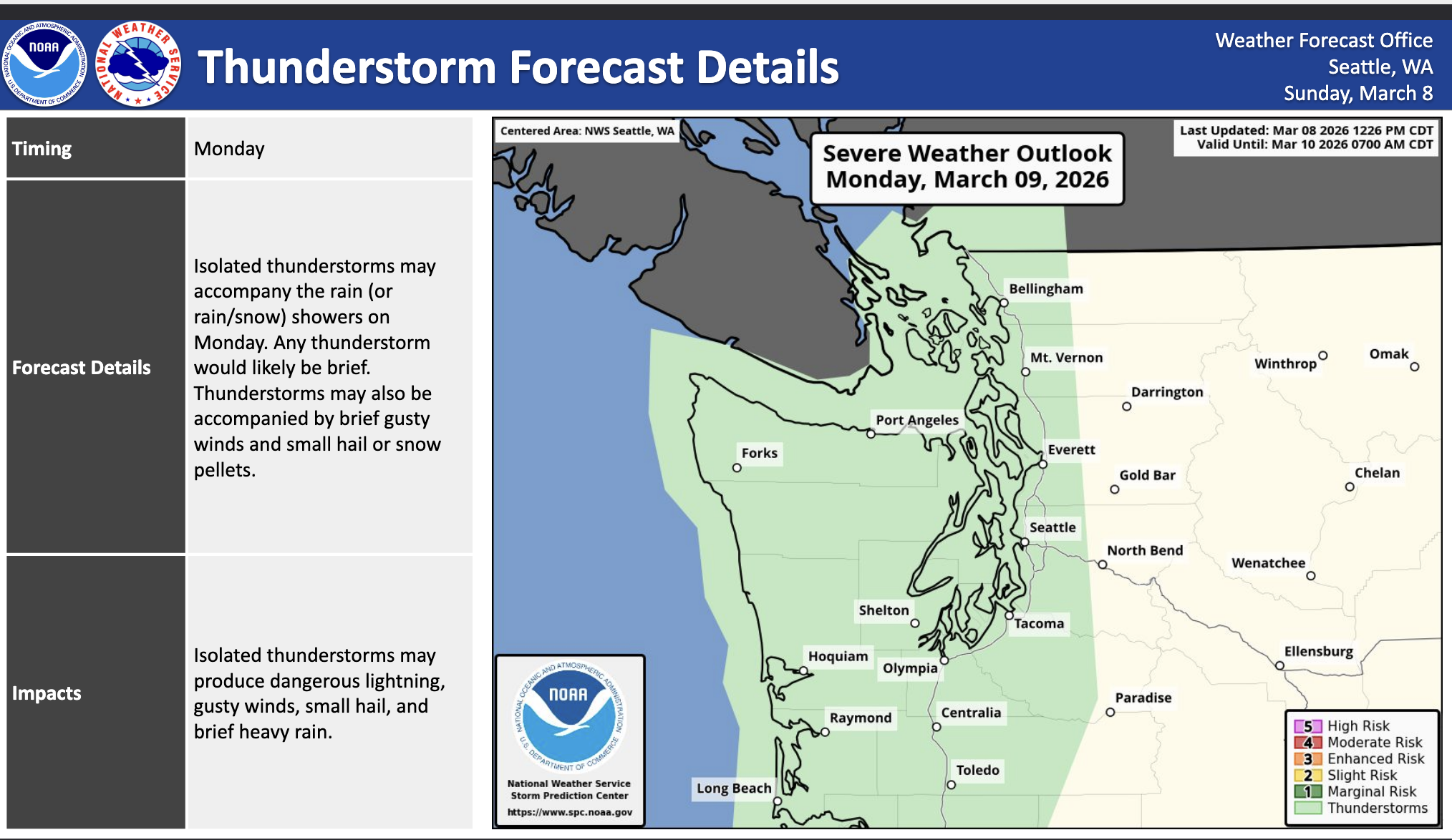
As we get through the day Monday, the air mass will remain cool and unstable, with scattered rain showers that may briefly mix with snow if the rain is intense enough. There is also a low but non-zero risk of thunderstorms.
Again, any snow will be brief and likely not stick for long, and temps will rebound well into the 40s between showers, quickly melting whatever survived. Best chances for seeing this wet get-your-hopes-up-but-don’t-really will be in the Convergence Zone and in the foothills above 500 feet.
The best-best chance for everyone will be late Monday night into early Tuesday morning where the air is a little cooler and the snow levels will be down to just a few hundred feet. We’re not looking at a hard freeze but a close-to-freeze that we can get some wet snow. And we’ll still have plenty of scattered showers running around and even still conditions ripe for a Convergence Zone floating around somewhere in northern King and/or Snohomish County.
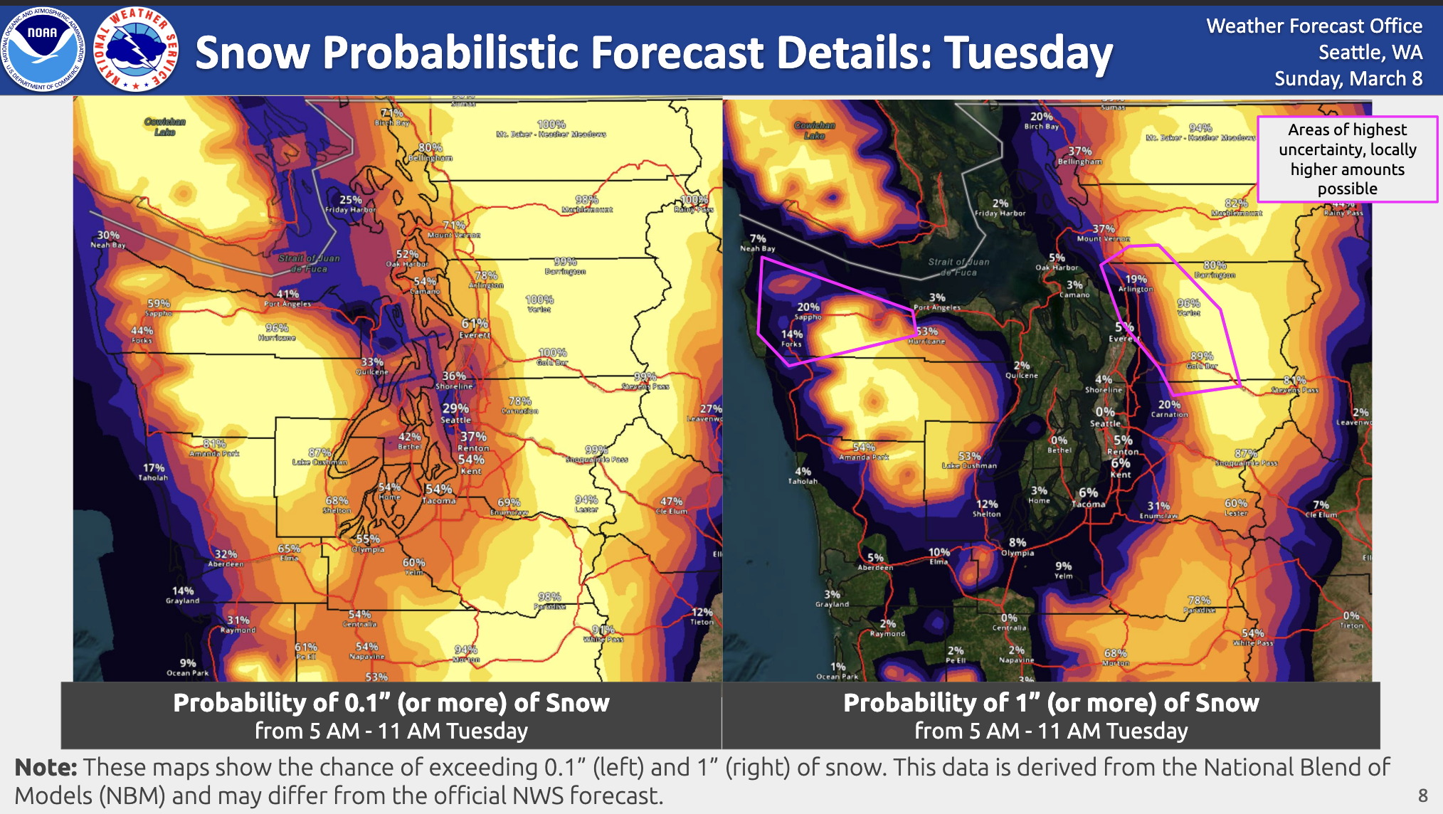
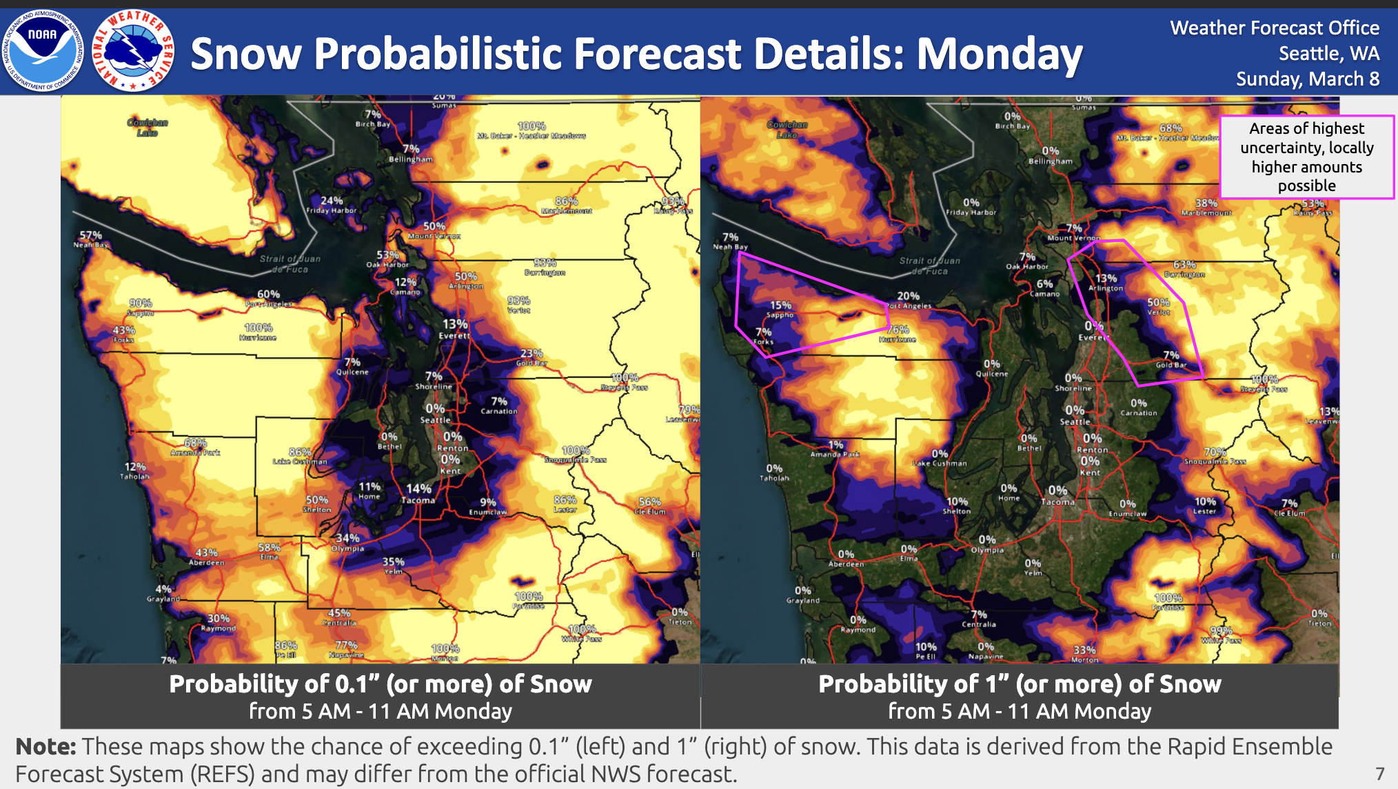
The NWS has a handy map that shows the probability of 0.1” of snow (technically measurable!) and more than 1”. Lots of places in the Puget Sound lowlands have a low to moderate chance of 0.1” or better, but almost no chance of 1” plus. That means it might briefly look white out your window but don’t get your hopes up for snowman building.
Temps will warm back above 40 as we get into later Tuesday morning and that will be it for our lowland now chances.
We do have Winter Storm Alerts up for the mountains in this first storm through Tuesday for 12-18” at Stevens/North Cascades and 6-10” at Snoqualmie Pass.
HERE COMES FEET OF MOUNTAIN SNOW
From late Tuesday through Thursday, the jet stream takes straight dead aim at the Pacific Northwest, fueling a train of cool, moist air that will slam into the western faces of the Olympics and Cascades, bringing gobs and gobs of snowfall.
We’re still looking of at least 2-4 feet of new snow (on top of the Sunday-Tuesday) and yes, the Euro model still thinks there’s a chance Stevens Pass gets close to 80-90” for a week-long snowfall total through Saturday and crossing the 100” mark next week…though not sure about that.
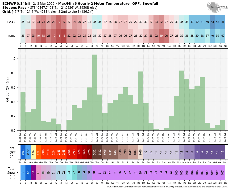
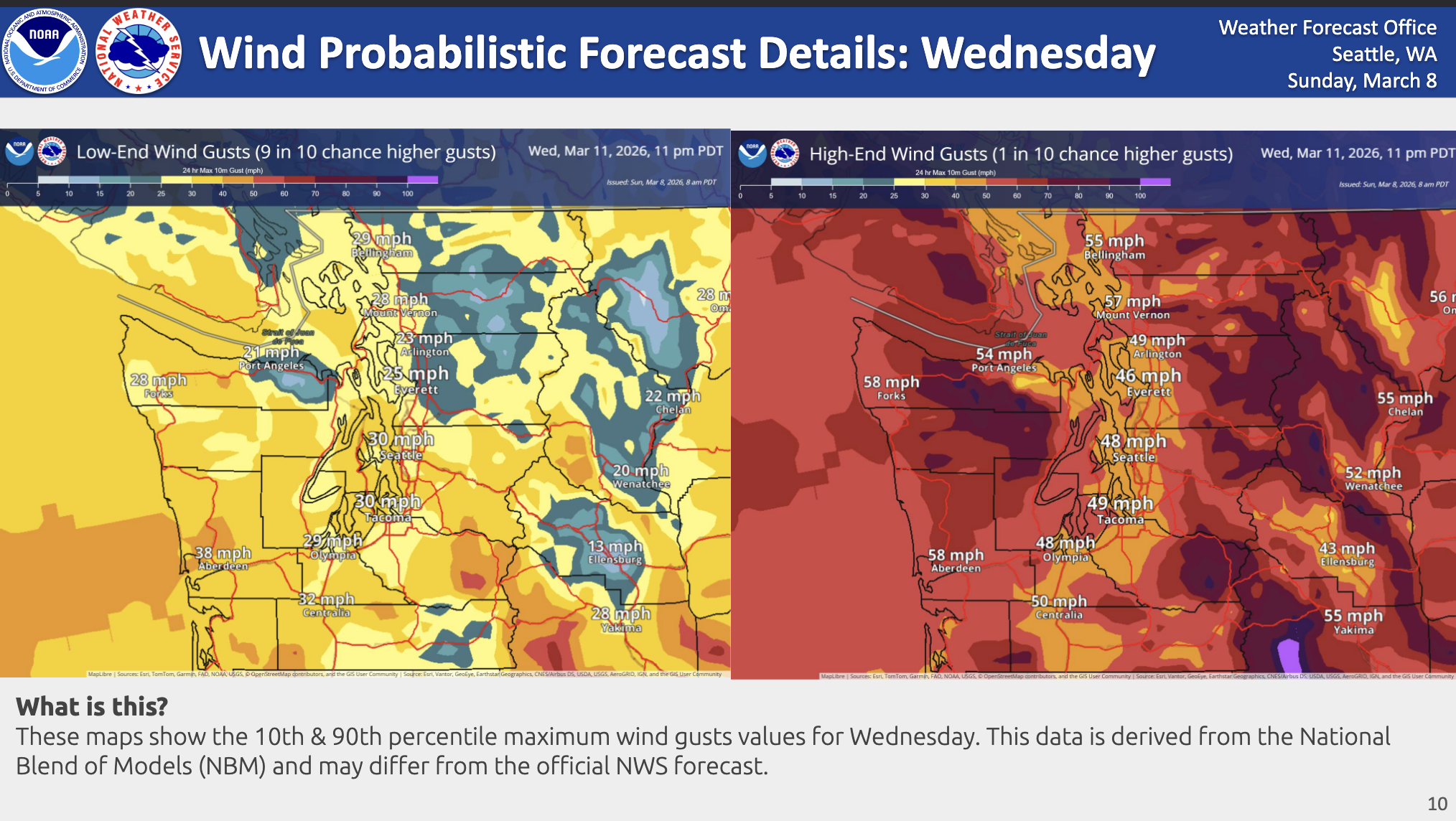
Winter Storm Warnings will be likely and with the wind speeds Wednesday I wouldn’t be surprised if maybe we get periods of blizzard-like conditions up there.
Mountain snow? 🌨️
Periods of snow will occur Sunday-Tuesday. Heavy snow is forecast for the Olympics & Cascades Wednesday & Thursday. Graphics show the probabilities of exceeding 1, 2, 3, & 4 ft of snow from Tuesday-Friday. Monitor forecasts if you’re traveling over the Passes! pic.twitter.com/sPfj3SHwXl
— NWS Seattle (@NWSSeattle) March 7, 2026
Thus, travel over the passes will get quite dicey. There is perhaps going to be a period late Wednesday and/or early Thursday where the snow level may briefly rise above pass levels as a low pressure center along the jet pulls some warm air up before cold air chases behind it and snow levels crash again.
For the lowlands, this will be a period of rainy, breezy weather that, depending on that low pressure center track, may bring a period of windier weather with gusts 40-45 mph or so.
We’ll keep an eye on that. Lowland snow chances are nil here as snow levels are back into the thousands of feet.
The steadier, heavier rain/mountain snow looks to taper a little on Friday and Saturday as we’re between storms but still under the influence of the strong jet stream just pouring moist air through the region, so still some wet days, just not as wet as mid week.
UH OH! I LOOKED AHEAD TO SEE IF THIS NOVEL WOULD EVER END AND I ACCIDENTALLY GOT SPOILERS. ARE WE REALLY GOING BACK TO WARM ATMOSPHERIC RIVERS AGAIN?
Some of the newer long range forecasts are at least trending toward keeping this intense wet pattern next week, but shifting its source more to draw moisture from the Hawaiian tropics. I’ve attached some of the maps showing some of the moisture plumes for next week. That… is very Pineapple Express-ey. Early pegs have high temperatures in Seattle in the upper 50s 😛
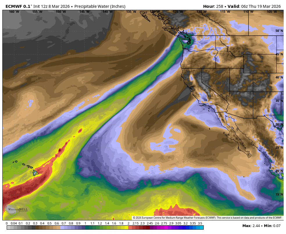
This is still 9+ days out so it can change. Though I also note that the National Weather Service is highlighting a “moderate” chance of heavy rains in the March 16-18 period.
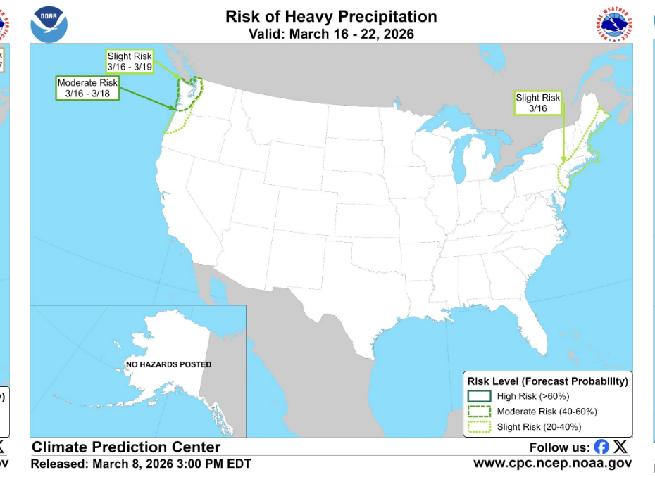
Some of those early forecasts indicate potential for several inches of rain (not snow 🙁 ) to the mountains.
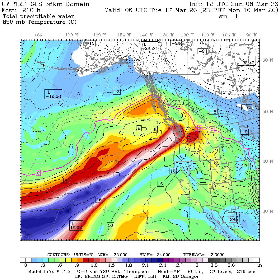
If those early maps verify, we could be looking at another round of river flooding. I love autumn and its pretty leaves and the occasional windstorm but I think we can all pass on an autumn call back to that kind of events.
WE JUST SACRIFICED AN HOUR OF SLEEP TO GET SUNLIGHT LATER IN THE EVENING. WHEN DO WE ACTUALLY GET TO SEE IT?
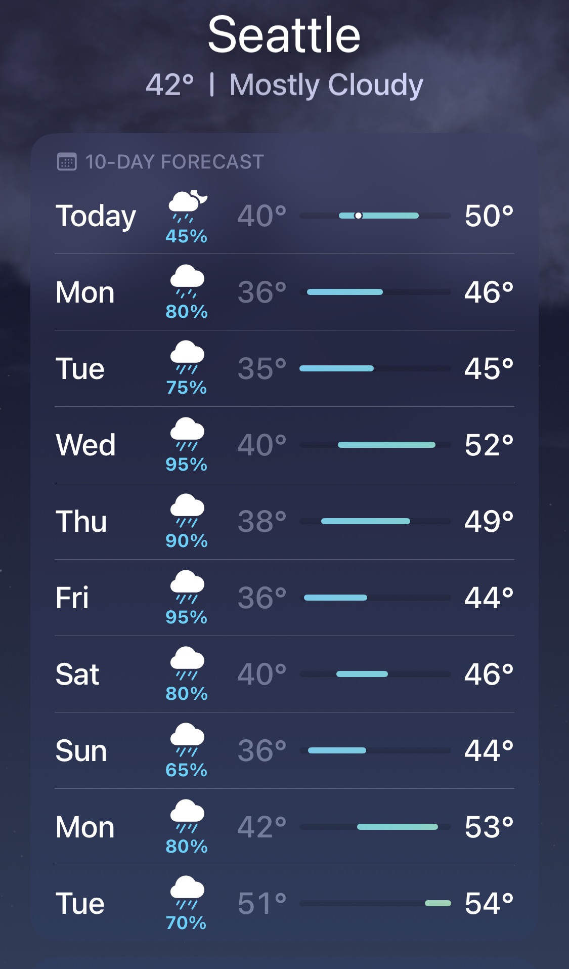
There is a significant chance of rain pretty much every every day for the next two weeks — for Seattle, the NWS has 100% chance of every day Tuesday through Thursday, and 80% book-ending it. My phone weather app for 10 days has 65% or better through all 10 days.
So sun fans AND lowland snow fans may need joint Emergency Kitten therapy then. Hmmm…. OK…