Photo by Stephen Plopper on Unsplash
(TL;DR: The Pacific Northwest is now forecast to have above average temperatures (in general) for the next year, but don’t believe the “historically hot summer” hype. Also: Pretty warm Tuesday; rain this weekend.)
First of all, happy start of Meteorological Summer! Yes, we weather folk measure summer from June 1-August 31 for ease of statistical bookkeeping. Don’t worry, the Summer Solstice is still on June 21, (and “Seattle Summer” is still starting on July 5th 😉 )
But with the start of the warm and dry season comes news that “warm”, at least relatively speaking, may not end when summer does this year.
Each month, NOAA’s Climate Prediction Center puts out fresh 90-day temperature and precipitation outlook maps that carry from the current three month period all the way out to a year from now. I’m sure you’ve seen them here and on other weather social feeds in the past. (They also do a corresponding precipitation analysis but I’m going to focus on the temps now since this is already a long post, but here is the link to see the precipitation outlooks. Spoiler Alert: It looks dry here…)
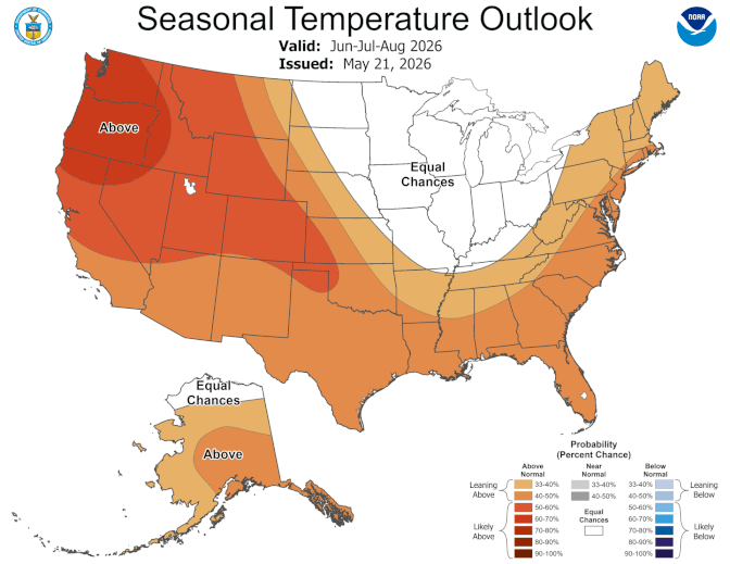
The latest updated batch, issued 10 days ago, is admittedly daunting. It’s the first time that I can ever remember every single 3 month period map stretching from now through *next* summer, indicating confidence of above-average temperatures in the Pacific Northwest :O I’ll talk about why later. (Spoiler Alert: El Niño)
However, I also want to debunk some hyper social media posts that are either innocently or maliciously misinterpreting what these maps really indicate. With already rampant hype over the El Niño/ “Super El Niño” coming, I’ve already seen some social posts declaring the maps mean this will be a historically hot summer and winter in the Pacific Northwest. But that’s NOT AT ALL what these maps mean.
So let’s break it down:
WHAT DO THESE MAPS MEAN:
What these particular maps are showing is a “confidence” level from NOAA climate forecasters in a region having average seasonal temperatures being above or below 0.5 degrees F.
So for example, if Seattle’s 3-month average temperature in the summer is 68 degrees, this is simply giving their confidence levels of the average being above 68.5 degrees.
In these darker-shaded maps attached here, forecasters give roughly 50-60% probability that period will end up warmer than average. That would mean about 30% chance of near normal temps and a slim 10-20% chance of below average temperatures. (Not “90-100% chance of record heat”)
WHAT THESE MAPS *DON’T* MEAN:
Conversely, these maps do not indicate intensity. For example, the above average shading would show the same map whether Seattle’s average was forecast to hit 68.6 or 85.2 if the confidence was the same.
So a darker shade doesn’t necessarily mean a hotter temperature forecast. Now you can look at it a bit like a darker shade would be like a favored sport team having a larger point spread. A higher confidence likely comes from knowing the number will more likely easily clear the criteria. Your confidence would likely be lower if your calculations came out to just barely crossing the threshold at 68.6 versus, say 70.4.
But crucially and what these hype posts don’t tell you, is that these maps are in no way predicting any “historic” heat or a redux of June 2021. I saw one AI generated map showing Seattle’s skyline with a 120 degree temp written on it.
NO.
That’s not what these maps would tell you. That’s not to say a June 2021-style heat wave couldn’t happen again this summer — though if it did that would be the most obvious sign there could be that the climate is “broken” as we knew it since that was on the order of a 1-in-1,000 year event. Then again-then again, we’ve seen similar style heat waves pop up since in other parts of the world — remember the Desert Southwest in late March.
But these maps are not where you’d find that forecast. It’s just not what they’re showing. It’s like showing a map of Missouri when you want to know how to assemble your new bookshelf.
WHY ARE THESE MAPS SO ORANGE FOR THE PACIFIC NORTHWEST THEN?
Tossing aside the “historic” heat aspect, these maps do paint a rather concerning trend for us, with high confidence of temps being above average in general this summer, fall, winter and even into NEXT spring and summer.
Climate forecasters use a mix of long range climate forecast models, any influences from the current El Niño/La Niña cycle, and recent trends like soil moisture —for example, drought can intensify heat waves as there’s less ground moisture to absorb heat and lets ground temperatures rise.
HELLO, (SUPER?) EL NINO?
No doubt one of the main factors driving our warm forecast is the near certainty of El Niño conditions forming this summer and winter with growing confidence it’ll be at least a very strong El Niño and potentially a historic one. (That’s where the “Super” El Niño is coming from.)
“By the late fall and early winter (October-November-December), there is near a 2 in 3 chance of a strong El Nino,” NOAA forecasters wrote.
El Nino’s are caused by warmer ocean waters in the Pacific Ocean. And that not only warms us up, but typically pushes the jet stream away from the Pacific Northwest in the fall and winter and into California, leaving us not only warm, but dry as a general rule.
A historic El Niño would be uncharted territory for knowing exactly what would happen, but past strong El Niños have led to very mild winters around here with below average snowpack both due the combination of high snow levels and lack of moisture.
“Given the increasing chance of a strong El Nino by next winter, above-normal temperature probabilities were increased to more than 50% across the northern tier of the (Continental U.S.), from the Pacific Northwest east to the Northern Great Plains, during Dec-Jan-Feb 2026-27.”
So yes, there are reasons it’s going to be warmer than average (and perhaps drier than average) for quite some time during the duration of this El Niño event, but it doesn’t necessarily mean it’ll be historic heat.
But it would NOT be good news for wildfire season, which in an extended dry and warm stretch could be more intense and last longer. And it’s worrying news for next winter’s snowpack prospects, which in turn could leave us with water shortages and more wildfire woes in 2027.
And speaking of which, NOAA does have unusually high confidence of hotter than average temps lasting into next summer due to the lingering heating effects of El Niño, even if El Niño itself fades by the late winter or spring.
WHEN DOES THIS ALL START?
Actually, not anytime soon. We do have a toasty warm day on tap in the Seattle area on Tuesday with mid 80s possible. However, we cool off quickly on Wednesday with a marine push… and rain returns to the forecast with a rather cool and robust system eyeing the Pacific Northwest at the end of the week into Saturday. The 6-10 day outlook is cool and wet for the Northwest but we look to rebound into warmer temps by mid-June.
Still every little rain system in the summer, be it meteorological or astronomical, is a huge help to mitigate the effects of any longer hot and dry stretches.