What are some scenarios a historic ‘Super El Nino’ could present for the Pacific Northwest and California?
 Scott Sistek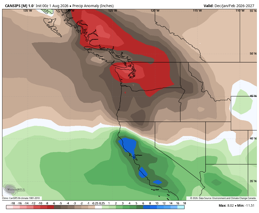
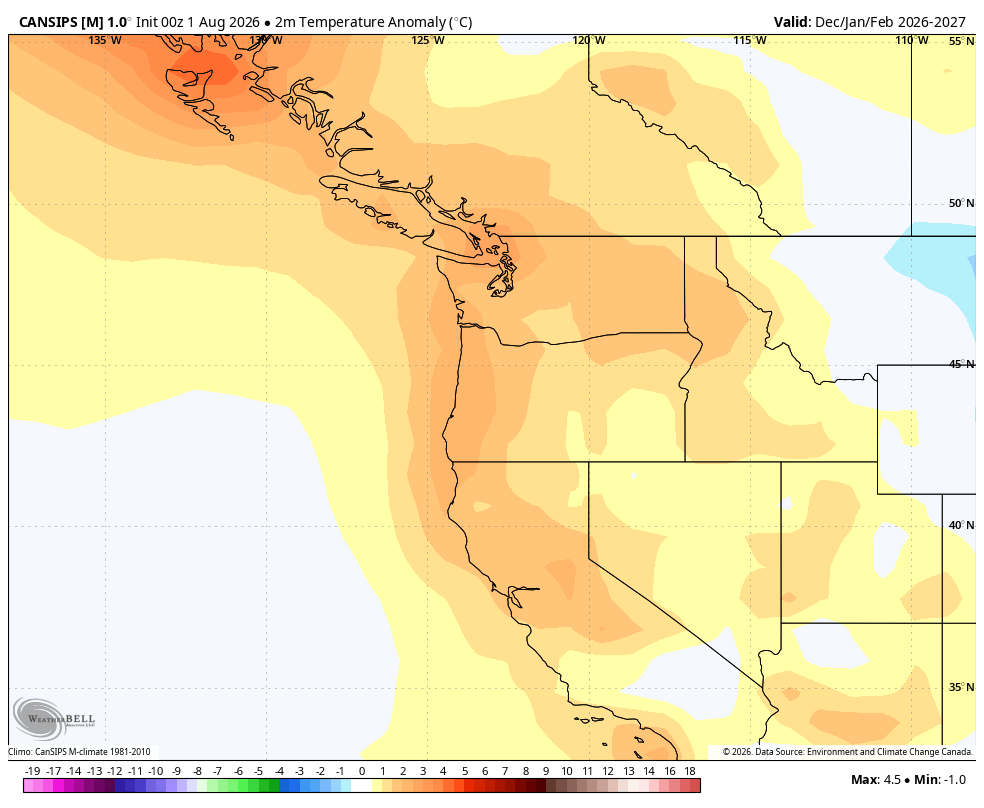
CanSIPS Model (Environment Canada) predicting well below average rainfall for this winter across the Pacific Northwest (but well above average in California)
If you’re like me and have any interest in weather, your feed here is likely already filled with stories about the impending El Niño, or as some might call it:
* Super El Niño
* Super-DUPER El Niño
* Supercalifragilistic(…) El Niño
* Godzilla El Niño
* Jeff*
(*-Actually that might be a LEGO Movie cat name…)
Many posts out there are full of hype and scary maps and declarations so I wanted to add in my thoughts and separate a bit of what’s fact from fanatical, and what I think this could mean for the Pacific Northwest this fall and winter.
WHAT IS EL NINO, AGAIN?
El Niño is part of the natural 3-7 year cycle, coupled with “La Niña”, where the ocean waters in the tropical Pacific Ocean warm (and cool). We’ve learned that these changes in water temperatures have chain-reaction events on the general weather patterns around the world by shifting areas of storm build-ups in the tropics. Currently, we’ve headed into the warm phase of El Niño after back-to-back winters of the cooling La Niña phase.
Water temperatures just being 0.5 degrees Celsius (about 0.9 F) above the climate average are enough to be counted as El Niño.
IS THIS REALLY A RECORD EL NINO FOR OUR LIFETIME?
Let’s begin with what most of these posts getting tossed around the internet are getting right: Yes, this is on track to be a historic event.
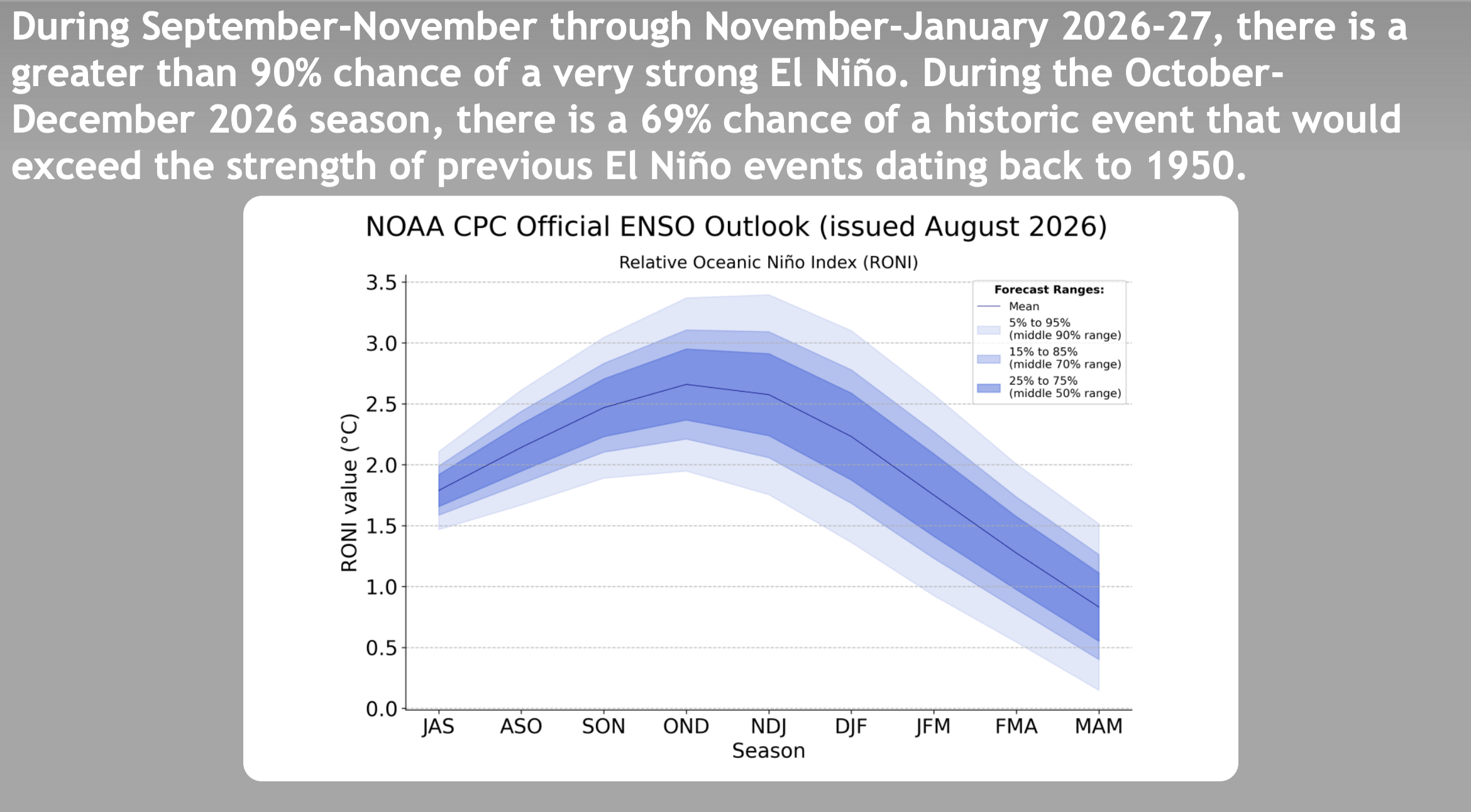
A lot of the hyperbole around the current and forecasted strength of the El Niño is true. Some of the forecasts are literally off the charts. NOAA’s forecast model chart that we’ve used for decades to show predicted ocean temperatures topped out at +2.5 degrees C warming at the top. They’ve had to keep adjusting it higher this cycle. Now even +4 isn’t enough for some of the climate model outputs.
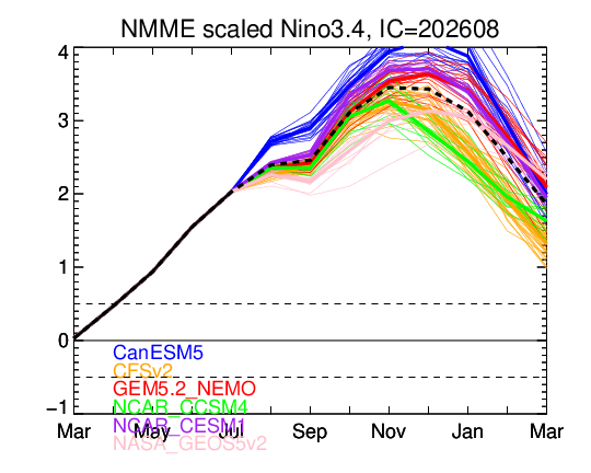
The strongest El Niños since we have data for (1950) have been the winters of 1997-98 and 2015-16. Both of those ended up around +2.5 degrees C for the peak water temperature anomaly. We’re already at +2 C now with sensors showing very warm waters lurking below the surface ready to give ocean temperatures another turbo boost.
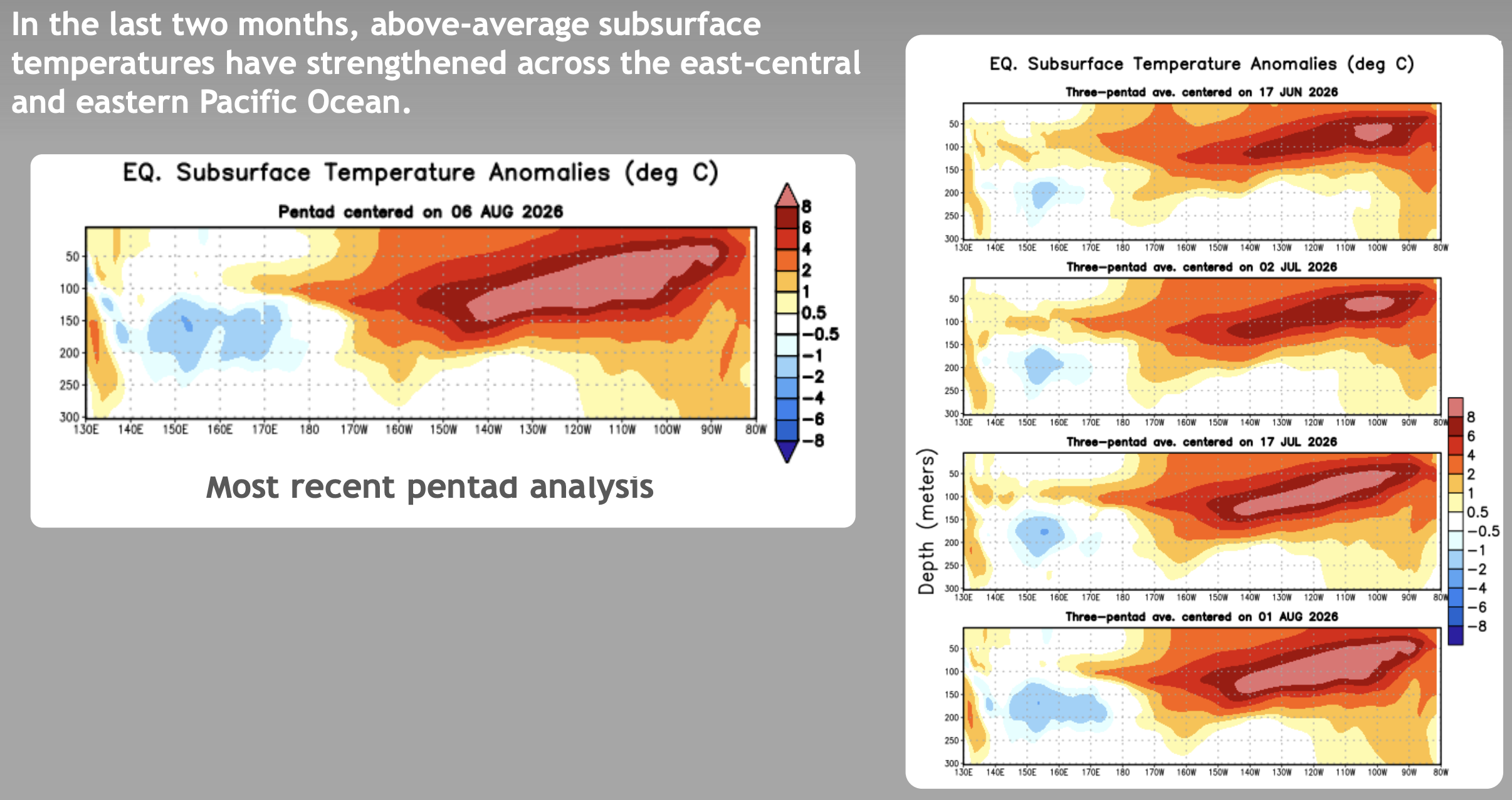
As a result, some of the forecasted peak temperature anomalies for this event exceed +3 degrees. Some of the outliers even go past +4.
NOAA doesn’t give a specific number for its forecast, but says it’s 100% probability of El Niño lasting into spring…
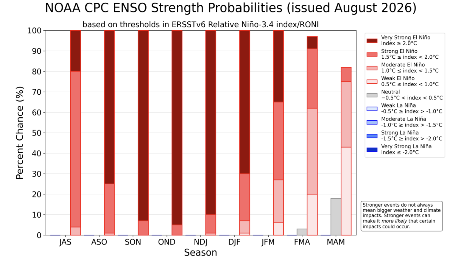
…and a 69% chance of a record strong El Niño — both higher confidence numbers than I’ve seen before.
SO WHAT DOES THAT MEAN FOR THE WEATHER THIS FALL AND WINTER?
First of all, let me caveat this by saying I am not a climate researcher. There are experts out there that are far more knowledgeable in the ins and out of these long term patterns vs the day to day weather forecasting I do. But below is my take on things…
We really *can’t* know what’s going to happen this fall and winter with this kind of El Niño. We’re going off script. If El Niño really does go over +3 or even bonkers beyond that, this will be something never before experienced during our weather record keeping periods.
Right now, many are using the guides of previous El Nino’s as a general forecast guide — specifically the aforementioned ones of 1997 and 2015. We know that past strong El Niños have a high correlation to certain long-term fall and winter patterns. It causes devastating flooding in some parts of the world; excruciating droughts in others.
For the U.S., El Niño tends to split or push the jet stream that usually pummels the Pacific Northwest with frequent rain and storms farther south across California and the South, leaving the Pacific Northwest and northern tier states with a usually drier and milder winter. Meanwhile, California has historically had multiple atmospheric rivers and flooding events in El Niño winters.
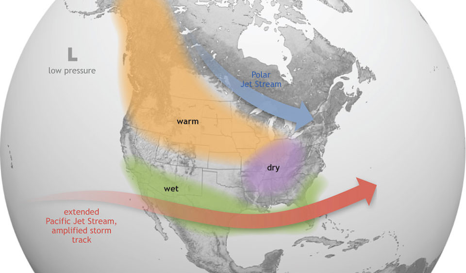
Mountain snowpacks here in the Northwest usually fare poorly in El Niño winters while are a boom across Sierra Nevada and central/southern Rockies. The South usually has more frequent severe weather events in the winter.
So that’s the El Niño “script”, but what happens when the “engine” that drives the weather patterns from El Niño goes into overdrive?
That is the million dollar question, and I think it’s a question we’re all trying to answer, but I don’t think we really should have too much confidence that the winter will follow that script. This goes back to: We haven’t seen this before. Could a super-charged El Niño be so strong that it overwhelms some of the “traditional” weather patterns and creates new shifts we aren’t expecting?
WHAT COULD BE IN THE REALM OF THE POSSIBLE?
Couple more caveats: I DON’T think we’ll see doom, apocalyptic scenarios some try to hype. It won’t look like scenes from The Day After Tomorrow out there. Historic El Niño may lead to more extreme weather events but not silly levels of extreme.
Also what scenarios I’m presenting below are NOT forecasts or expectations. Just spitballing some past historical events that have already happened in the past in Seattle and the West — so not fantasy land — but we haven’t seen in a while… that I could see a scenario where they resurface within the support of such a wonky atmospheric setup.
1. Atmospheric Rivers on overdrive
Warmer water temperatures mean more moisture available for storms to carry, as warm air can hold more moisture. With much of the Pacific Ocean running warm, this could bring more powerful rain storms and revved-up atmospheric rivers.
MORE: What does an ‘atmospheric river’ mean?
Right now the focus for these type of flooding storms remains across California, as they’ve had a long history of terrible flooding seasons during El Nino winters. Could record El Niño lead to record rain storms as the jet stream conspires with warmer waters? It’s a scenario California emergency planners are taking seriously. California has had some floods in their history — particularly 1862 — that brought devastating levels of rain they haven’t seen since, but are in the climatological record as realm of the possible.
But we should be on guard up here in the Northwest too as it’s important to note that even if El Niño goes generally “on script” and keeps the jet stream mostly into California, it doesn’t *always* stay there. A short term shift in the pattern could temporarily steer some of that moisture up here.
1997’s Super El Niño ended up with somewhat near normal precipitation in the Northwest — because many of the storms were so geographically large going into California that we still got he northern edge of the rain up here. The 2015-16 winter ended up wetter than average in the Northwest too, bucking the general El Niño trend.
2. Seattle gets a 4+ inch day of rain?
Along the same lines as above, Seattle (Sea-Tac) has only had 7 days in its history (since 1945) with 3+ inches of rain in a day, last done Dec. 20, 2019 (though we had 2.97 inches on Feb. 28, 2022.)
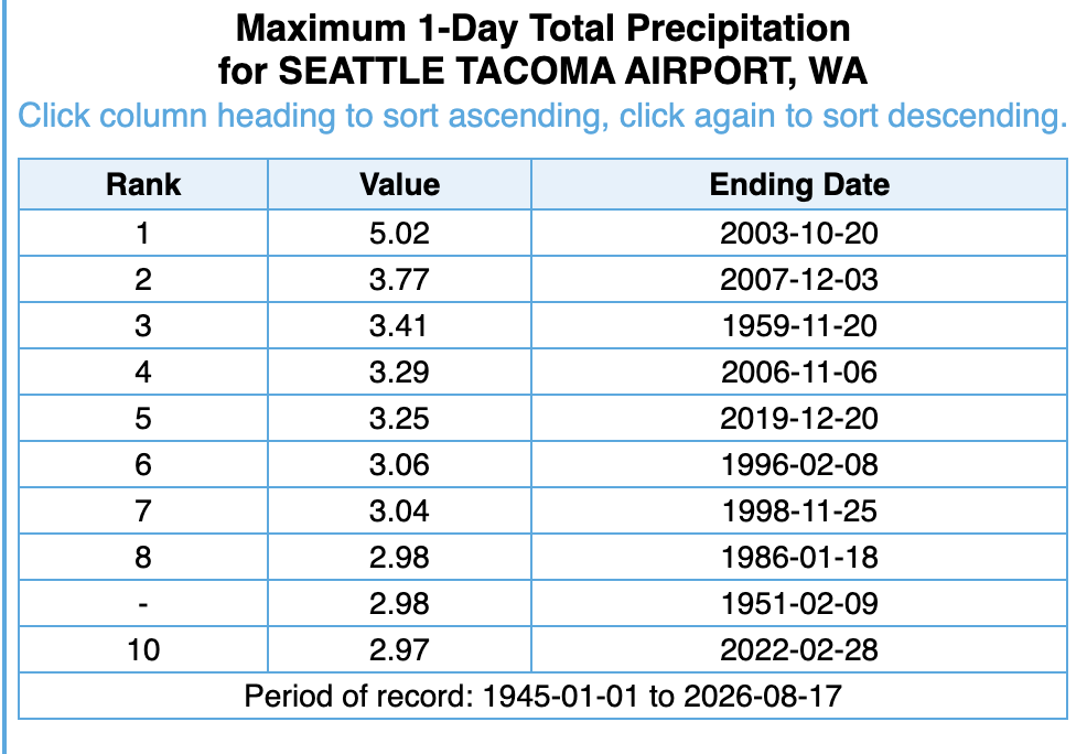
But Seattle has had only one day with 4+ inches of rain — our still-standing record of 5.02 inches set on Oct. 20, 2003. El Niño’s script would dictate these kind of storms would stay south of the Northwest, but if a strong storm gets nudged our way instead?
3.Sneaky snow event in Seattle?
Generally, El Niño winters are marked by poor lowland snow seasons for Seattle and Western Washington (plus dismal mountain snowpack) as it’s drier than usual, and when we do get precipitation, it’s too mild for snow.
I’d suspect that would be the case again this winter. NOAA for some still unexplained reason decided to stop tracking snow from 1997-2003 (DON’T Ask…smh) but Seattle went two consecutive winters from the Super El Niño of 2015-2016 with a grand total of 0.8 inches of snow.
But a scenario I could see maybe with a monkey wrench of a record El Niño — if the whacked-out ocean sets up an anomalous winter ridge of high pressure over Alaska — that could temporarily force some arctic air down into the Pacific Northwest. Then if you brought a warmer, wetter El Nino-fueled storm on top of it, you’ve got a possible December 1996 scenario where you have gobs of heavy snow turn to a warm, heavy rain event. I know several carports just shuddered at that sentence. Dec. 26-29 Seattle had 12-18” of snow turn to 2+ inches of rain and 50+ degrees making a royal mess around here. (Also has that really been 30 years since that snowstorm?!? :O )
We did see this pattern happen somewhat last winter in the Northeast, where a big warm winter ridge set up in central Canada, shoving a batch of arctic air into the Northeast and they got a big snow storm despite an overall mild winter.
Again, not saying it’ll happen, but I can see a scenario. Overall though, I’d lean warmer/drier as this winter’s theme and think good thoughts for ski resorts trying to hold on after the last few disappointing seasons.
4. 68 degrees in the winter?
I *don’t* think we’ll spend the entire winter with eye-popping warmth that has snowbirds reconsidering how far south they really need to go. 2015’s winter, currently the warmest on record, was also heavily influenced by “The Blob”. For those that weren’t here, that was when we had a big pool of warm waters also off our coast, not just the tropical Pacific Ocean.
That winter was marked by no high temperatures below 50 degrees from Feb. 1 through Nov. 14. January and February had 8 days of 58 or warmer, including 4 days over 60. But aside from that, while most days ran warmer than average, it still *felt* like winter outside. If we do get warm Pineapple Express storms our way, that could temporarily spike temps though.
5. Tropical system into California?
This is a wild card “guess” from me. But El Niño years super charge the Pacific Ocean tropics season (and suppress the Atlantic Ocean season). We’ve already seen several tropical systems out there including Hurricane Lala that recently sideswiped Hawaii.
But California?
The ocean waters off southern California are usually way too cold to support a direct hit from tropical storms, which need at least 78 degree water to survive. (SoCal water temps are usually in the low 60s.) But the state has actually had two documented tropical system strikes in its history — a tropical storm that hit Long Beach in 1939 and a hurricane that hit San Diego in 1858.
For that kind of scenario to play out, you need ocean waters off Mexico to be much warmer than average (check) to give tropical systems a longer runway. And then the missing ingredient (but possible with all the tropical activity out there) would be a storm to get caught in an upper level wind pattern that could steer and race it toward Southern California.
It’d need to have enough speed to use the longer runway of warmer waters and survive the weakening process of the colder California ocean temperatures — and still have enough momentum to make it ashore while still a tropical storm. Heck, one of the long range 15 day models last week briefly toyed with this idea with a tropical system forming off Mexico, but had the weakening storm aim for San Francisco (!) (it quickly gave up the idea).
Again, I’m not predicting or forecasting this will happen. I’m just saying if there were a year for California to try for a third, this might be the setup. On the other hand, California is well versed with getting similar impacts from tropical remnants of storms that fizzle out in the cold waters. I’d think that would be a more likely scenario they’d deal with this autumn. The remnants of Hurricane Hilary three summers ago are a good example.
Overall though, I suspect much of our fall and winter will be rather mundane — perhaps too mundane being mild and dry, but typical El Niños usually have the Pacific Northwest on the sidelines. The official long range seasonal forecasts still indicate high El-Nino-fueled confidence of a warmer and drier winter across the Pacific Northwest.

We’ll see if this El Niño follows suit or if “Jeff” brings a whole new script to the season.