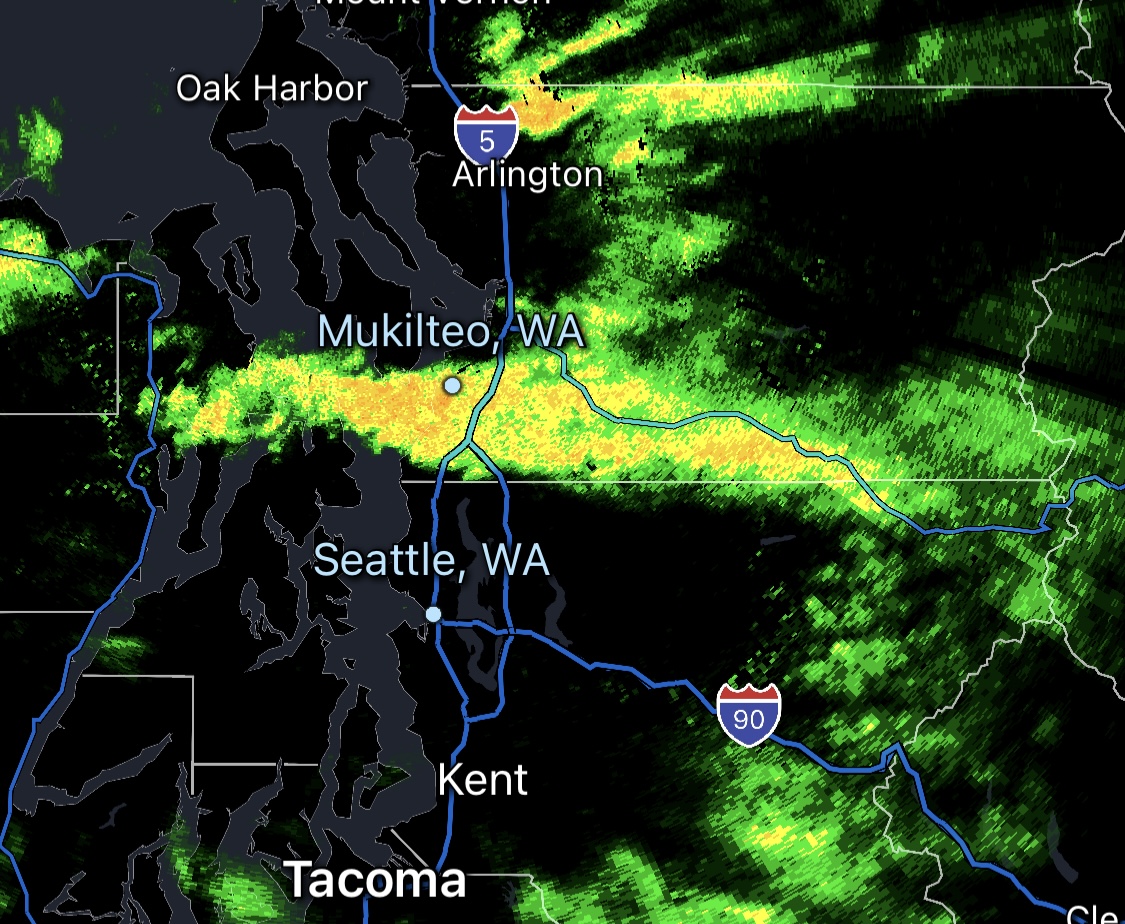
Puget Sound Convergence Zone radar from Dec. 26, 2025
One of the most famous — and infamous — microclimates in the Seattle area that can bring headaches to forecasters and residents alike is the Puget Sound Convergence Zone.
What is it and how is it formed? Basically it’s when the weather — the wind, specifically — does the splits.
Much of the time around here the winds are out of the south/southwest, but after storms systems and cold fronts sweep by, the winds will shift to coming from the northwest.
Over on the northwestern coast, those winds come smack dab into the roadblock Olympic Mountains, which act like a traffic cop. Some wind will detour to its left where it then flow eastward down the Strait of Juan de Fuca and into the Northern Puget Sound area, where they then turn to the south.
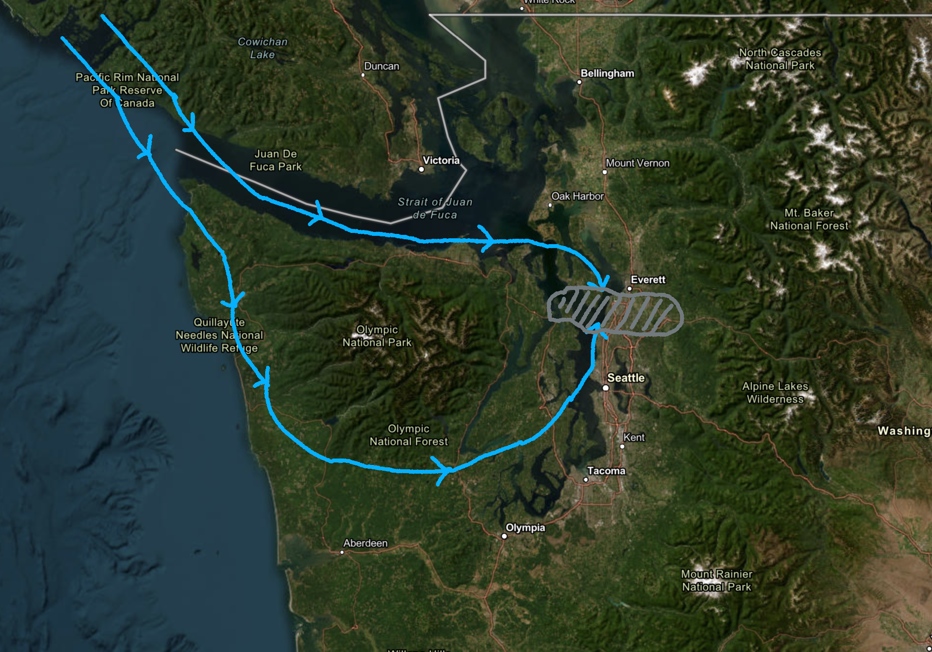
Other air gets deflected to its right, flowing south down the coast until it beds to the east around the southern flanks of the Olympics and toward the South Puget Sound area, where they then turn to the north.
These two split winds then collide somewhere over the Puget Sound area making a “convergence zone”. The collision is important, as where the winds collide, air are then pushed upward, and now you’ve created a cloud- and rain-making convection process. The air cools and condenses as it races skyward, creating clouds and rain.
WHO GETS THE PUGET SOUND CONVERGENCE ZONE MOST OFTEN?
The PSCZ’s favorite hangout place is in southern Snohomish County and into northern King County as that is the spot where the winds most frequently collide.
Edmonds, Lynnwood, Mukilteo, Mill Creek, Bothell, Brier, South Everett, Woodinville, and Shoreline are all considered “home turf” for the zone. Those that live there know this all too well.
But the battle zone for the winds can stretch along a line several to dozens of miles west-to-east, many times even reaching from the Kitsap Peninsula across the Puget Sound and into the I-5/I-405 corridors — and even into the Cascades.
Yet the zone is usually only a few miles wide from north to south. Meaning many times it is a very narrow corridor that is getting rain… or weather chaos, with neighboring cities under calm — and even sunny conditions.
But to add another layer of forecast difficulty, depending on the strength of each component of the wind, the zone can form about as far north as Everett and as far south as around Burien and Sea-Tac Airport.
And that zone’s location can fluctuate as each component of the colliding winds ebb and flow — allowing the zone to drift north, or south, or stay relatively stationary for hours, relentlessly drenching areas.
Or, all of the above.
A typical PSCZ evolution will be for the zone to form in its usual Southern Snohomish County spot, then gradually sink south into North Seattle and the Eastside in the following hours as the northerly wind component gathers more steam and pushes the zone south. The zone will carry through Downtown Seattle and Bellevue before stating to fizzle as it passes the southern edge of Lake Washington.
But not always. And therein lies the forecasting headache.
CONVERGENCE ZONES CAN GET PRETTY STORMY TOO…
In the wake of more potent storms, when the atmosphere becomes more unstable — as in, when cooler air behind a strong cold front floods in aloft, allowing increasing convection and juicing the rain creation process — Convergence Zones can bring torrential rains, lightning and hail.
In the winter time, it can make for sudden and intense snowfalls. If you go look up the crippling Downtown Seattle snowstorm of Dec. 18, 1990 where 12” fell in short order, that was a PSCZ.
And when the convergence zones get over into Stevens and Snoqualmie passes, it can create epic snowfalls that turn the roadways into treacherous snow-blinded adventures.
WHEN SHOULD WE BE ON GUARD FOR PSCZ?
Most of them form in the hours after a storm passes, but PSCZ’s can linger for several hours or even into the following day or two if northwest flow continues.
DOES THE CONVERGENCE ZONE OFFSET THE OLYMPIC RAIN SHADOW, THEN?
You might think then the Convergence Zone brings more rain to the North Sound then but it’s a trade-off. The North Sound gets more rainy days, but overall, gets less rain than Seattle.
Why?
The North Sound gets the fringe effects from the Olympic Rain Shadow, which means on days when it’s raining across much of the area, it rains a little less in the North Sound as the Olympics block some of the rain.
Overall, southern Snohomish County gets on average about 160-162 days with measurable rain a year — roughly a week more than Seattle does.
But by annual rainfall, Seattle gets about 39 inches per year on average, while Southern Snohomish County gets a little over 33 inches per year.