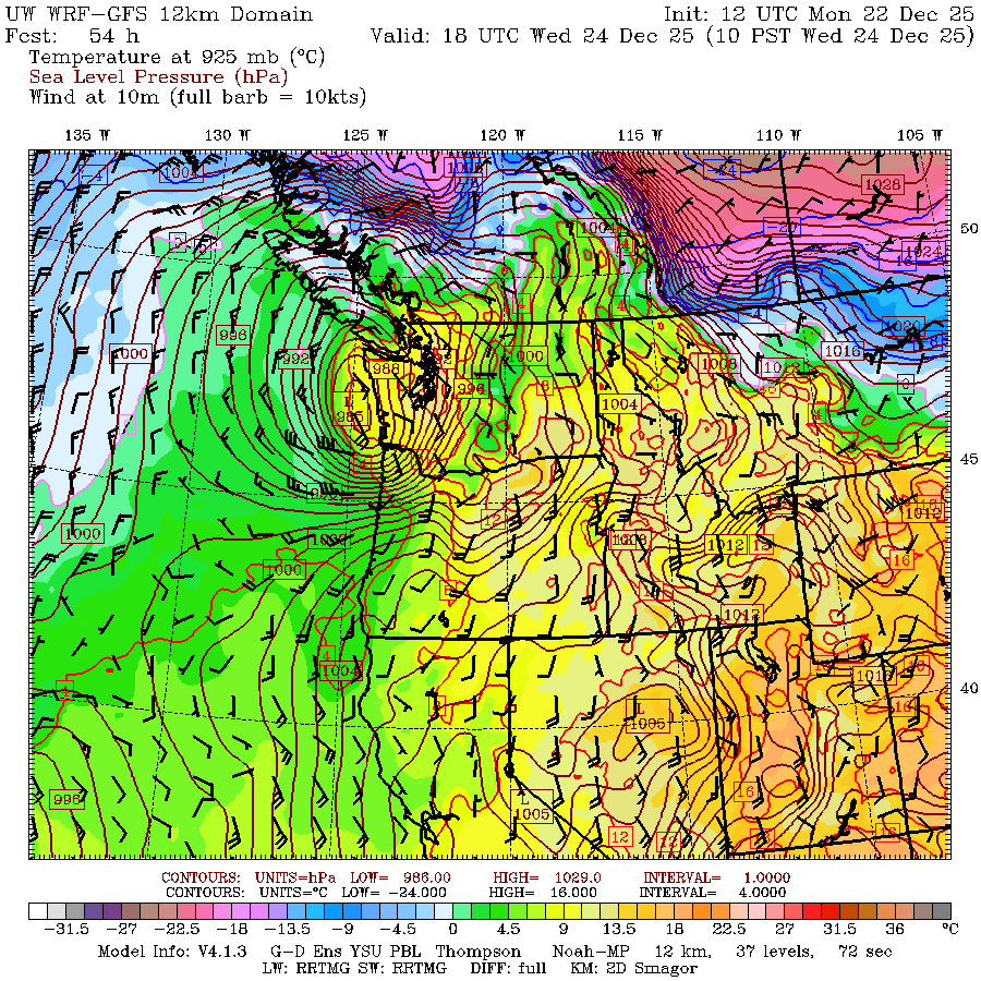
UW WRF-GFS model predicting potent low just off Washington coast on Dec. 24.
A new wrinkle has popped up in the forecast this week as an incoming storm has potential for impactful winds right in the heart of Christmas Eve afternoon and evening. But it is a HIGHLY unusual storm track for us and at this point has VERY HIGH potential to bust and leave us with pretty much a calm day.
Fa-la-la-la-laaaa….
I’m going to start by saying what I’m writing below is right now the “what would happen if” scenario but there is **very low confidence** in this forecast right now. This post is under the guise of “be prepared”.
THE POTENTIAL SETUP
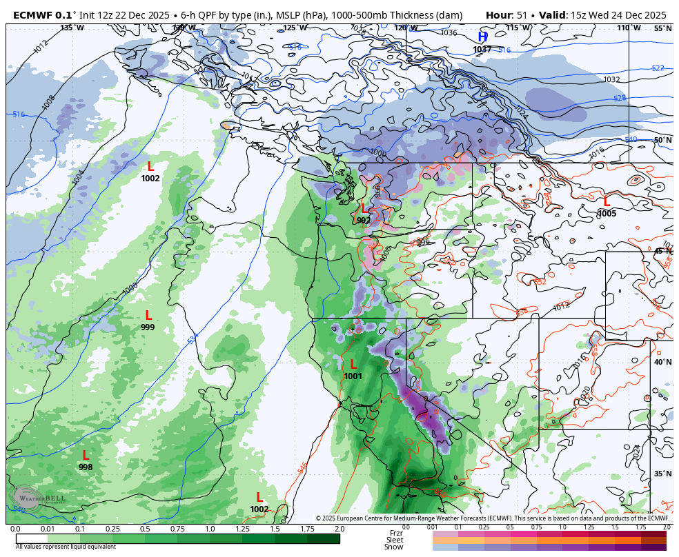
All of the atmospheric rivers and stormy weather talk has been focused on California the past several days, but some forecast models are now picking up on a potent low pressure center far off the coast of *Southern California* and then making a race north up the Northern California coastline as it gathers steam. From there the forecast gets hazy — does the low just plow inland, in which case it’s harmless for us in the Northwest, or does it continue to strengthen and track north up the Oregon coast… and then maybe even Washington coast into B.C.?

In this case, the strongest winds would be “chasing” the storm behind to its south — picture like large wake behind a speeding boat if the speeding boat is our storm center, only it’s wind, not water.
The farther the storm would make it north, the more wind potential we have in Western Washington. If at any point along the journey the storm turns inland before getting to us (like the boat turning away before it got to you) — as many computer forecast model runs right now are saying — we’re off the hook and there will be no significant weather here.
But a decent amount of model forecasts paint possible scenarios where the storm tracks just offshore of Washington or is coming right up the I-5 corridor on Wednesday afternoon. In that case, we get the full “brunt” of the wake (wind) in my metaphor and initial forecasts suggest if so, potential for widespread wind gusts of 50-60 mph.
Right now the timing IF the storm happens would be early to mid afternoon on Wednesday. The storm would come rather suddenly and go by pretty quick, just a few hours. There is also a scenario in there if the low passes by just to our west, that it could briefly spike a few hours of strong east winds through the foothills and mountain passes a short bit before the southerly winds arrive.
But again I just want to really reiterate that we have less confidence than usual in a storm especially for one so close to happening.
WHAT WOULD MAKE THIS STORM SO UNUSUAL?
Most of our classic windstorm tracks make their approach from about offshore of the California/Oregon border region then come from more of a southwest direction and head northeast. The wind events we’ve had this year so far have the winds come as the storm sweeps from west to east (ish).
This storm would be a south-to-north (ish) track. And while many other storms have a period where they curl north offshore before heading inland, this storm is unusual having its origins so far south.

And then for it to be forecast to maintain such a direct northerly track for so long, scraping the entire West Coast as it does so? I don’t really recall a storm doing that before, so I’m leaning a bit skeptical as it would really have to tiptoe a tight rope for that peak impact track.
Yet some of the forecasts are there, so let’s heed attention. It’s not just potential for a Seattle/Western Washington event; if the stronger scenarios play out it, the storm could bring impactful winds across the Northern California coast, the entire Oregon coast, and, if it pushes far enough inland, into the Portland and Willamette Valley areas too.
We’ll be keeping an eye on this for sure. Let’s hope the pessimistic models are right and it just turns inland before it has a chance to do much development and this was all much ado about nothing.
Sounds like a similar path that the Columbus Day storm took.
Thats an interesting yet ominous observation. I really hope this doesn’t materialize. The Northwest has been through more enough extreme weather lately.