How ‘triple gravity effect’ brings significant coastal flooding threat to Northwest during January
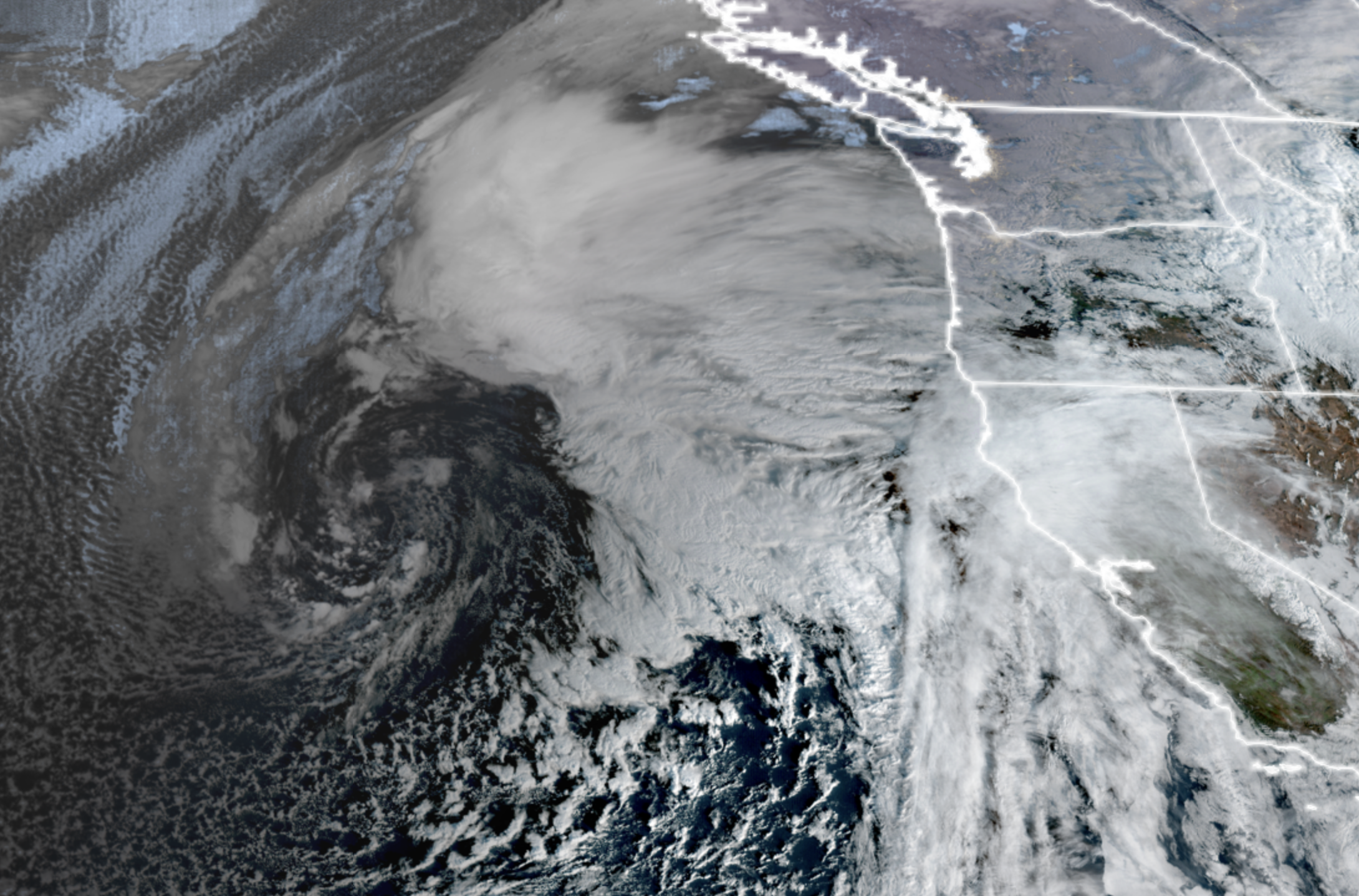
GOES-18 Satellite image for Jan. 2, 2026. (NOAA/CIRA/RAAM-B)
It’s a perfect storm this weekend… of gravity that is mixing with a regular garden-variety atmospheric storm that will conspire to bring large “king tides” and potential for significant coastal flooding along the Washington coast— and even a bit on the inland waters as well.
Much of the flooding work is being done by the moon and sun. This weekend represents the time of this month’s full moon, which is when the sun and moon are aligned to enhance their gravitational effects on our tides. That, of course, happens every month.
But this month we also have a “supermoon” — as the full moon phase is coinciding with the time when the moon is making its closest orbit to Earth this month (the Moon’s orbit is elliptical so there are times when the moon is slightly closer than others.) With the closer moon, that adds just a little more to the gravitational tug.
THAT’S TWO— BUT WE’VE GOT *3* GRAVITY ENHANCEMENTS!
January 4-5 also coincides when the Earth’s orbit brings it to its closest point around the Sun. (Fun fact! We’re about 3 million miles closer to the sun in January than we are in July.)
So we are in a triple alignment where the sun and moon are on the same orbital plane, while the moon is at its closest point to the Earth and the Earth is at its closest point to the sun. Those slight extra gravitational tugs give rise to the higher than average “king” tides (or “spring” tides).
BUT WAIT, THERE’S MORE!
With tides already running high, that leaves us vulnerable if another agitator comes along to boost the tides even more. Right on cue, here comes another storm.
Low pressure centers have two effects on tides. Lower atmospheric pressure gently “tugs” on the surface of the water and can help pull sea levels a little higher like a weak, but widespread vacuum.
And storms rolling in off the coast can bring in higher waves and a small “storm surge” as winds push the waters ahead. Usually those two items are insignificant and not really noticeable, but in this case they’re adding just a little more to the already high tides, enhancing the flooding risk.
COASTAL FLOOD WARNINGS IN EFFECT
To that end, the National Weather Service so far has a Coastal Flood Warning in effect for Friday’s midday high tide for Westport and Grays Harbor County along the coast for potential of 2-2.5 feet of flooding above ground level.

But the highest flooding potential is Saturday and Sunday at peak full moon + storminess.
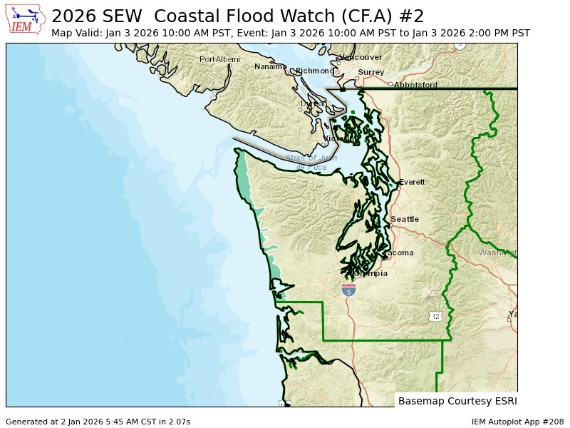
A Coastal Flood Watch is in effect for the North Coast and Westport/Grays Harbour County again for possible “significant coastal flooding” of 2.5-3 feet above ground level along shorelines and low-lying coastal areas.
“Numerous roads may be closed,” NWS Seattle said. “Low lying property including homes, businesses, and some critical infrastructure may be inundated. Some shoreline erosion may occur.”
High tides both Saturday and Sunday are around the 12-1 am/pm time frames.
Inland areas around Puget Sound and Salish Sea shorelines may also see some tidal flooding this weekend.
This is just tidal flooding threats only; there is not enough rain in the forecast for river or urban flooding.
WHAT ABOUT THE REST OF US?
Aside from the tidal issues, the weather over the next few days is pretty Seattle-usual. We’re in a lull Friday morning but showers return Friday afternoon and evening.
The storm that’s helping enhance the tides comes in later Saturday and lasts through the night before tapering off Sunday. We’ve been talking about potential for gusty winds and while that is still the case, it’s looking more likely that gusts will stay below impactful levels.
Right now the leading scenario is for breezy winds to pick up late Saturday night and blow into Sunday morning, tapering off around sunrise or so. Gusts look to peak around 30-35 mph now in the Puget Sound area, with perhaps some gusts to 40-45 mph along the coast and Northwest Interior, but we should be able to shrug those off now.
The storm is on the mild side so not a great mountain snow maker. But our next storm is looming around Tuesday next week – this one should be a cooler storm (temperature wise, but maybe it wears sunglasses too…) and should be better at getting some new mountain snow.
Much like the Earth, Moon and Sun this week, we’ll be pulling for that scenario 🙂
This reads like it’s written using AI. The language is awkward and words are misused.
This weekend does not “represent” the full moon. The full moon occurs this weekend.
I look forward to reading weather discussions that are more thoughtful and meaningful. In the meantime, I suggest using another source for weather information.
“Much of the flooding work is being done by the moon and sun. This weekend represents the full moon which is the time when the sun and moon are aligned to enhance their gravitational effects on our tides. That, of course, happens every month.” What does this even mean?
It means we have a full moon when the earth and moon are fully aligned. That’s why we can see the full face of the moon. It also means their are gravitational consequences on Earth and tides from these two sources.
Triple gravity??? Wow three times the gravitational force? Will we even be able to walk around during the full moon? 🤦🏽♀️🤦🏽♀️🤦🏽♀️🤦🏽♀️
I think he means triple the gravitational effects that act on the tides. Obviously not triple Earth’s gravity. You seem really nitpicky. Did you get dumped by the writer or something? I really enjoy this free blog. It provides a lot of detail compared to every other local weather source.