November ends up warm; Skiers give 2 thumbs down to early December outlook
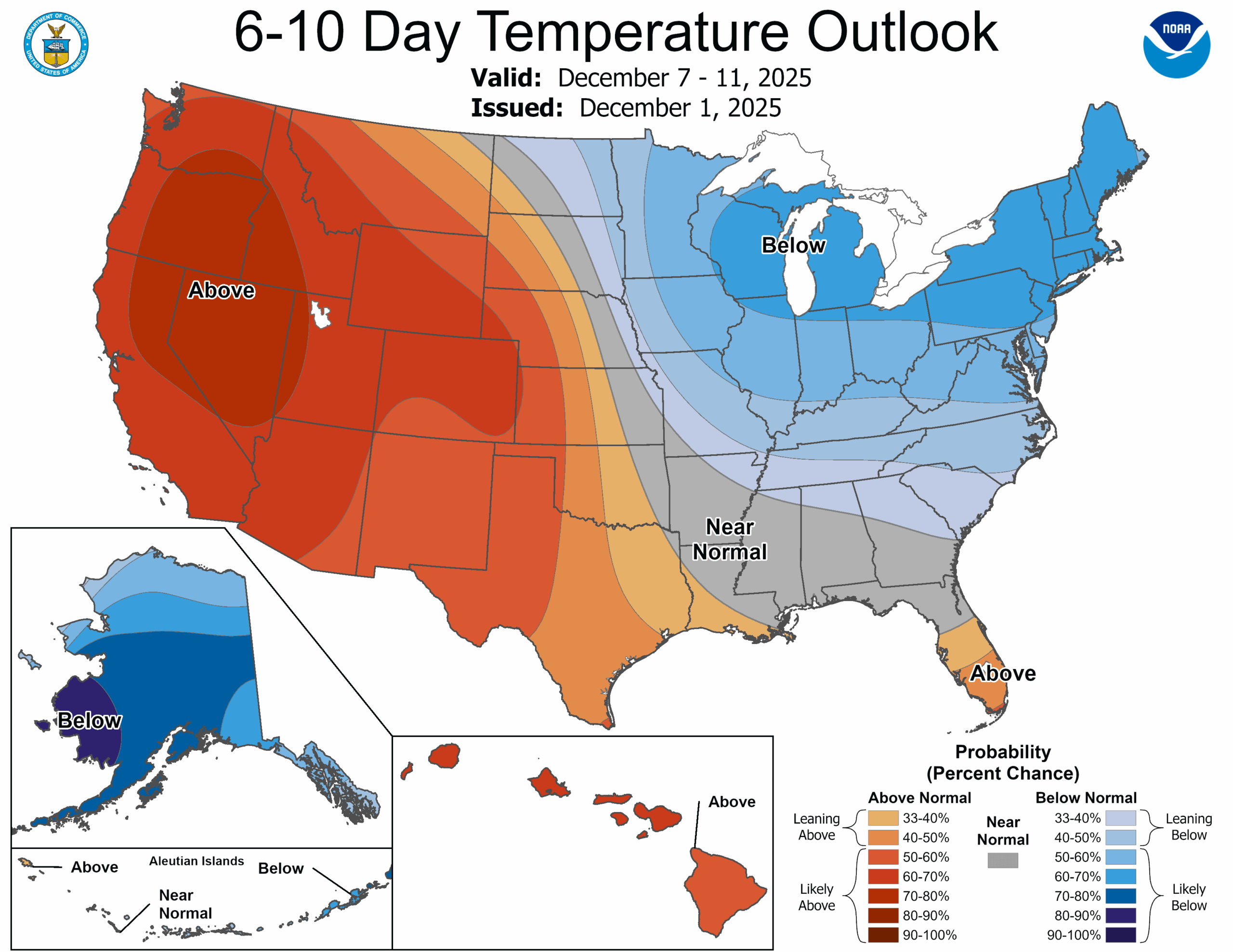
6-10 day forecast for Dec. 7-11, 2025.
Meteorological Winter is now upon us (Dec. 1-Feb. 28) and I don’t want to say it’s time for Emergency Kittens-level concern yet for skiers and snowboarders in the Cascades. But… “Meow”?
November was pretty wet and occasionally stormy like most Novembers are, but the main culprit has been the mild air that has kept snow levels high during the bulk of the precipitation.
Seattle’s average high temperature was 53.5 degrees — well above the average of 52.1 and the 12th-warmest on record at Sea-Tac. Rainfall was 5.71 inches — just a bit below the average of 6.31 inches. So plenty of moisture, just too warm for snow.
(FYI, if you felt it was gloomy, the month ended up at 83.6% average cloud cover — 5th cloudiest since I have records back to 2004.)
MORE TO EXPLORE:
- Multiple atmospheric river storms loom in weekend forecast, threatening flooding in Cascades
- Why did Seattle’s snow forecast map look like this earlier this month?
- The Thanksgiving deluge of 1990: Record floods and a sinking I-90 Bridge
- ‘I have to get the baby’: A Vancouver mother’s sacrifice during the Northwest’s deadliest tornado
Snoqualmie Pass has 2” of snow at the WSDOT station and a season total of 18 inches so far. Last year we had 11” on the ground and 38” for the total.
Stevens Pass has 10” on the ground at WSDOT gauge and 36” for the year so far. Last year was 21” on ground and 55” total. Last year ended up a bit below average for the season.
A paltry snow in November isn’t too unusual but usually if not, December quickly starts to catch up, especially in La Niña years.
We’re still waiting (that originally auto corrected to “wailing” and… maybe that too?)
The long range models from the middle and end of November showed promises of much colder weather in the offing for late November and early December and… promises not kept. Most of that arctic air went east as the ridge of high pressure that was supposed to sit well offshore and drive cold air south into the Pacific Northwest, instead set up shop right off the coast, keeping us drier and mild and pushing the cold air east.
The weather pattern is in the middle of a change again, but we’re reverting back to what we had at the start of November: Wet, but mild.
(Actually, it could be REALLY wet. We’re starting to see potential for impactful heavy rains later this week into the weekend that may bring flooding concerns.)
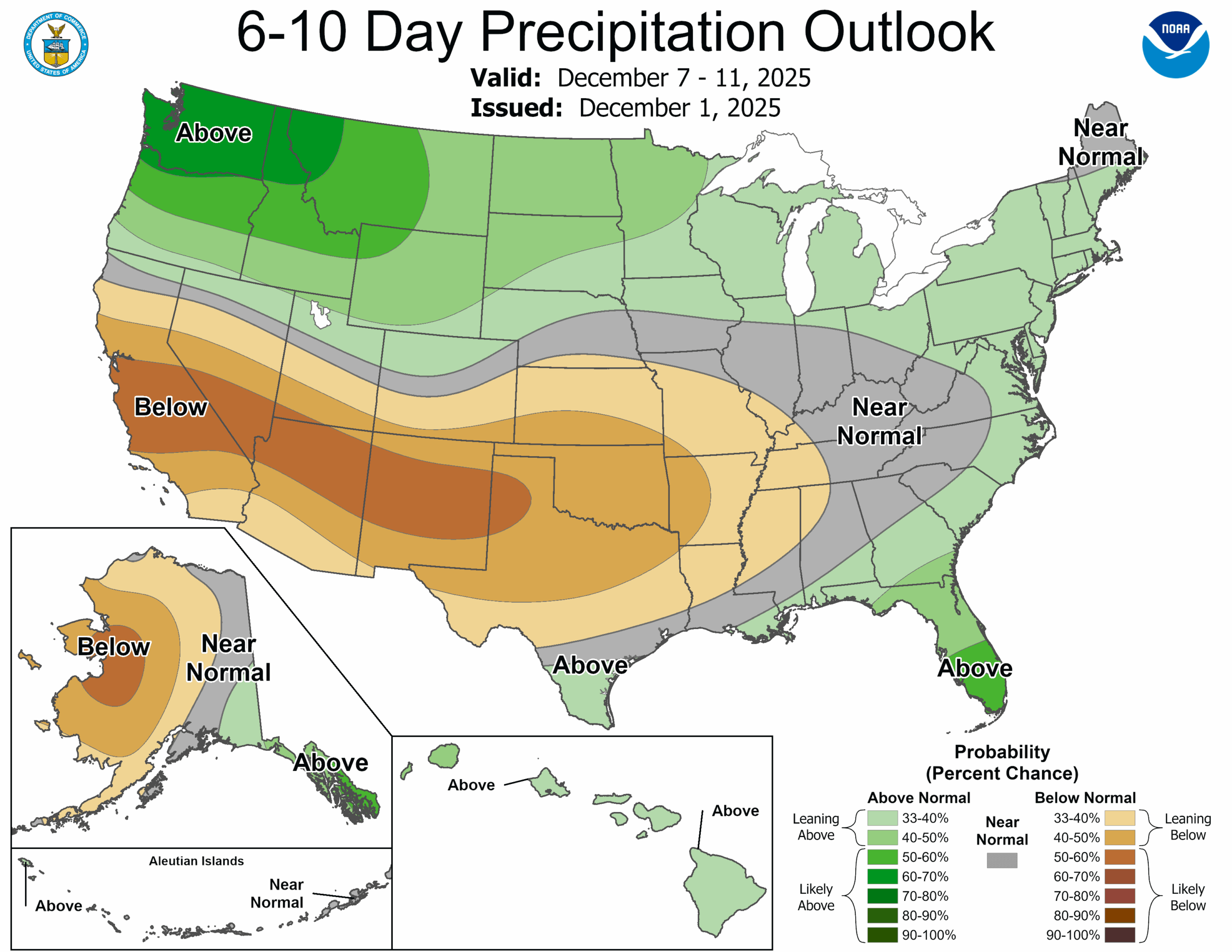
The 6-10 day forecast (and the 8-14 day forecast) both show high confidence of above average temperatures and above average rainfall. There might be a few periods in there where like early November, snow levels temporarily drop and we get a brief period of snow in the lower elevations, but then the next storm warms right back up and we melt a lot of it.
Meh.
The good sliver of news is that NOAA says our La Niña out in the Pacific is holding firm — it even took a bit of a brief stronger dip to the cooler side in recent days before bouncing back to where it had been. If La Niña can still hold on, and if it could maybe even end up a touch stronger than predicted, that could have some good news for the middle and later parts of the ski season as it ski resorts have a better signal of snowier weather with a moderate (instead of weak) La Niña and it could stretch out La Niña to let it last longer into winter.
So hang in there skiers and snowboarders! In the meantime: I got you!