1-2 punch of strong atmospheric rivers trigger flood threat in Cascades, Olympics
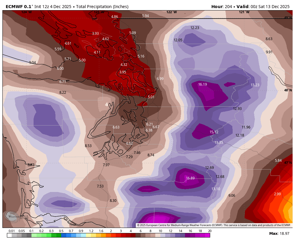
ECMWF model showing predicted 5 day rainfall totals across the Pacific Northwest through next Friday
The series of atmospheric river storms forecast to take aim at the Pacific Northwest early next week is now forecast to be among the stronger events we typically see in an autumn or winter, and now at least one river forecast to reach “major” flood stage.
The meteorologists at the Center for Western Weather and Water Extremes — the keepers of the atmospheric river forecasts and data — are forecasting a Category 5 (the highest rung on their rating scale) atmospheric river to reach the Pacific Coast next week, though in their latest updates, have dropped the forecast to a Category 4 for the Washington coast next week.
MORE: ‘Godzilla atmospheric river’ targets Seattle area with major flooding and landslide threats
While not on par with an extreme rating like a Category 4 or 5 hurricane or an EF-5 tornado, a Category 5 Atmospheric River means that the storms inherently hazardous to the region with potential for major river flooding.
The forecast generally remains on track: Essentially multiple storms coming in succession, with more Friday, Sunday and then the larger atmospheric river storm Monday through Wednesday.

The Friday and Sunday storms are wet (wetter than Thursday) but not impactful yet. Mostly they are just playing the role of starting to fill the rivers so that they’re already straining when the strongest storm(s) of the bunch comes in next week.
Forecast models remain still consistent with at least 3-4 inches in the Seattle-area lowlands of combined rainfall totals with 5-10 inches of rain or more the mountains.
Some of the more aggressive models are going as much as 5-6 inches of combined rain in the Puget Sound lowlands over the full week of storms and over a foot of rain in the higher mountains, which would really create some landslide dangers in addition to widespread river flooding.
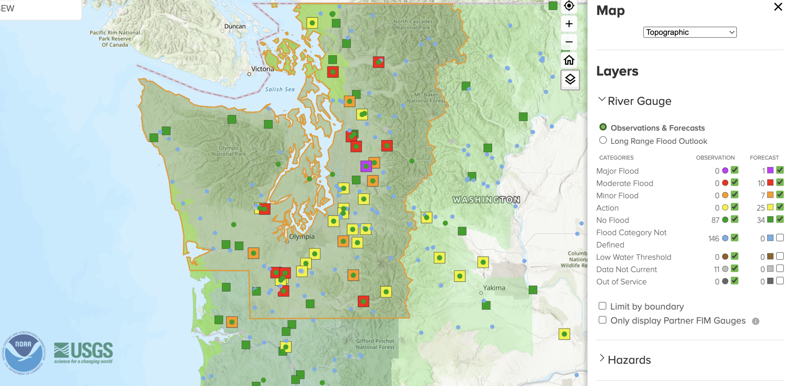
Multiple rivers now forecast to reach ‘moderate’ to ‘major’ flood stage
Flood Watches now cover much of Western Washington from Monday through Friday.

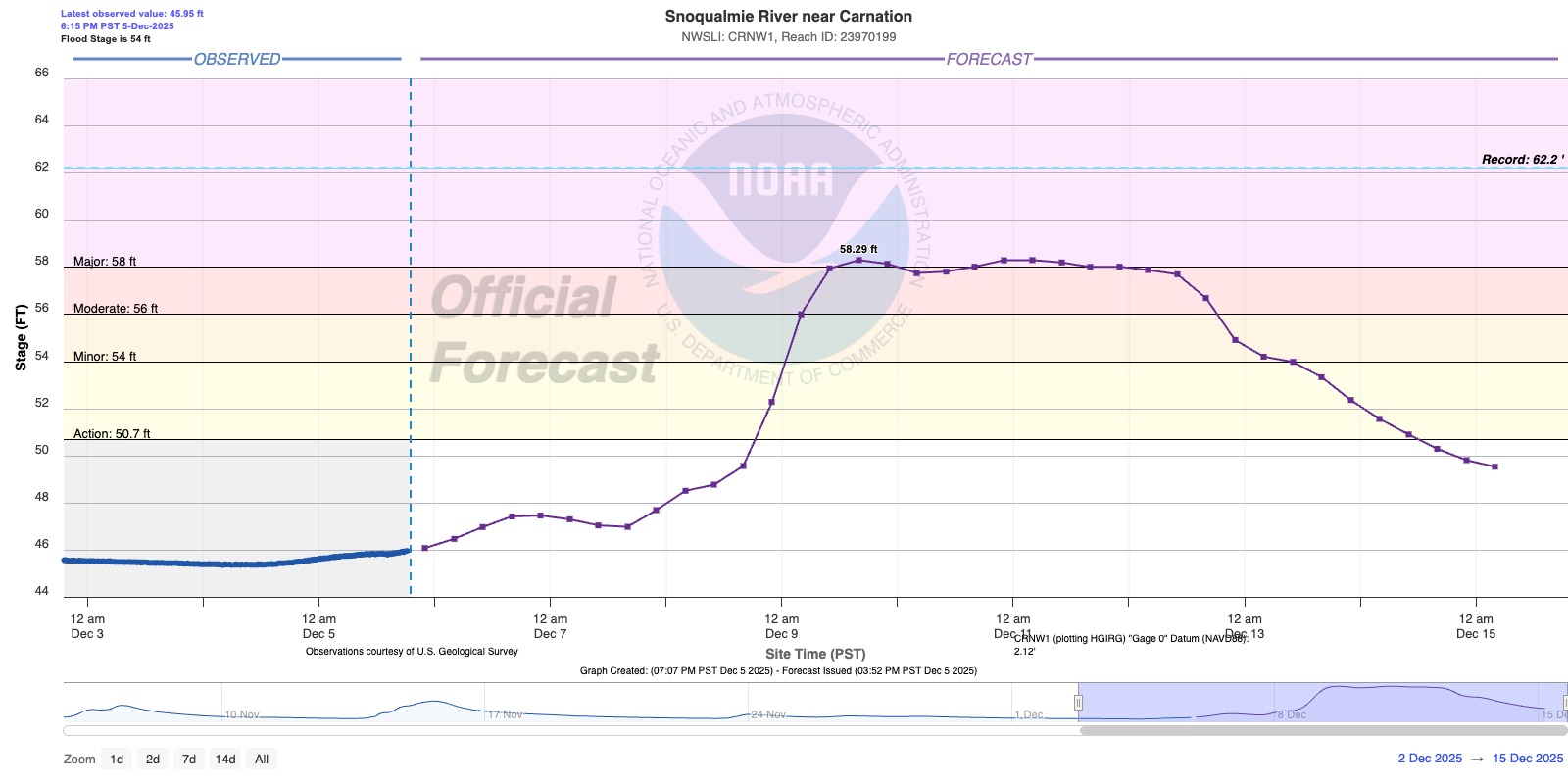
The latest forecasts from NOAA’s National Water Prediction Service say that the Snoqualmie River near Carnation could reach “major” flood stage and remain there for up to three days.
Several other rivers, including the Snohomish River near Monroe and Skagit near Mount Vernon have had forecasts flirting with major flood stage.
For the Snoqualmie River at Carnation, the current predicted peak is about a half foot higher than the floods of Dec. 6, 2023, but a little more than a foot below the March 2022 flood. But more daunting — the forecast as of Friday evening is now for the river to remain around major flood stage for three full days from Tuesday into next Friday morning.
For the Skagit River, the predicted peak at Mount Vernon is just a foot shy of “major” flood stage and is 1 foot above the Dec. 2023 floods, but still nearly 7 feet below the near-record flood of November 2021.
Meanwhile, several other rivers are expected to reach at least minor (orange box) to moderate (red box) flood stage next week: (See latest river forecast map here)
Vulnerable rivers look to reach flood stage around Tuesday.
The atmospheric river should fade by later Wednesday but there may be additional rain toward the end of the week.
MORE TO EXPLORE:
- Legion of Gloom: Dark days ahead with relentless stormy stretch across Seattle area
- How does Spokane have sunsets in the 3 o’clock hour this week?
- What does an ‘atmospheric river’ mean?