Another stormy, blustery day triggers wind alerts across parts of Western Washington
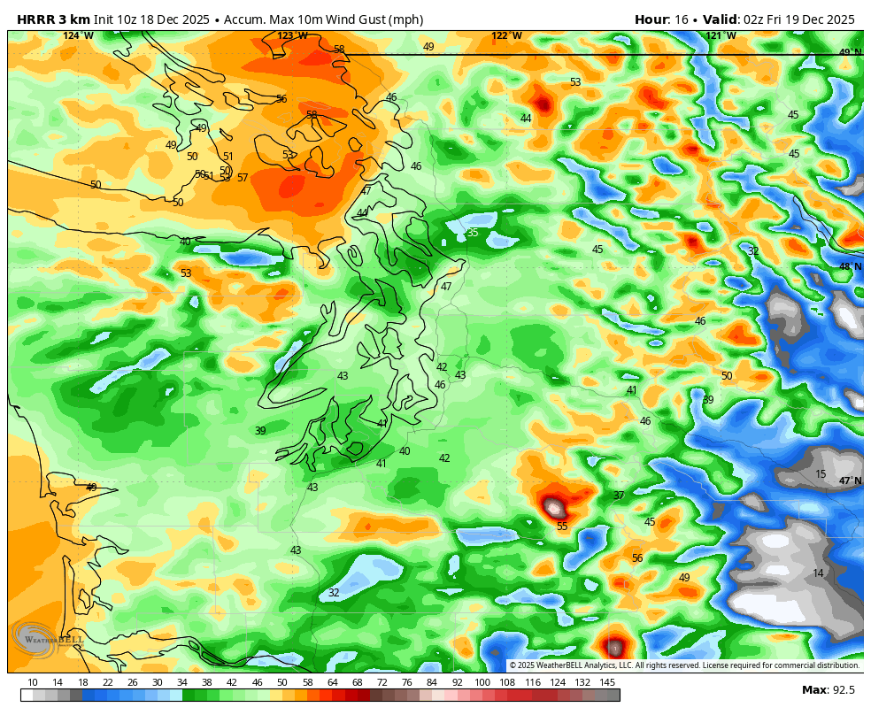
Peak wind gusts for 6 p.m Thursday Dec. 18
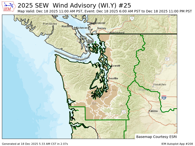
It’s not quite exactly “here we go again”, but fresh off Tuesday’s windstorm, there’s fresh wind alerts posted for parts of the region again Thursday.
But overall this is more of a nuisance wind than an impactful wind with the exception of two places: Whidbey Island…
And Lumen Field.
Yet another atmospheric river is coming into the Pacific Northwest on Thursday but this time it’s focusing its rainy punch on Portland and northwestern Oregon, though we’ll still get the northern edge.
It will make for a generally rainy day here, with heavier rains from about Tacoma/South Sound south into Oregon. We still have several rivers lingering in Flood Warnings from earlier in the week but Thursday’s rains won’t be a significant agitator.
But the storm will bring another round of blustery winds. Wind Advisories are posted in three “blobs” around the region: The coast, the far North Sound and the South Sound/Southwestern Washington. Seattle/Bellevue/Everett and much of Kitsap County are in a “Wind Alert Doughnut Hole” today (feel free to steal for a speciality doughnut name, Top Pot Doughnuts! )
Winds inside the alert will peak generally around 40-45 mph from about midday or early afternoon Thursday into Thursday evening — sort of what’s become “atmospheric river storm standard” and we’ve seen multiple times this autumn. The exception are the San Juans, Whidbey & Camano Islands and the eastern Strait of Juan de Fuca areas where another surge of westerly wind looks to roll through Thursday evening, but not as intense as Tuesday night’s event. Maybe some gusts to 50-55 here and renewed power issues :/
For the “No Wind Alert Donut Hole” area of core Seattle Metro area, we’re still looking at gusty winds this afternoon and evening around 30-40 mph peaking….right about the time the Seahawks game kicks off and staying blustery through the game.
For those going to the big game tonight, the steady, moderate rains should shift south of the stadium before game time but it will still likely be occasionally wet and very blustery. If by chance Seahawks coach Mike Macdonald follows this blog (If so: OMG! Hi!) this is not a game where we want to rely on Jason Myers to kick 6 field goals or attempt 60+ yards to win it 🙂
For the rest of us, it’s a rainy, blustery day. If you need to get over I-90, the mountains will go through a brief warm up this afternoon/evening where we could squeeze in a few hours of just rain at Snoqualmie Pass (though there may be a brief period of freezing rain in the transition to rain, so check pass reports before you go), but snow levels will plummet back under pass level as we get into tonight.
Friday’s weather into the weekend and Christmas week, much like the NFC West, is best described as “unsettled”.
The atmospheric river train is choo-chooing its way south and is set to pummel the San Francisco Bay Area and Central California for several days, and you’l likely start seeing headlines similar to our recent impacts down there.
Up here, a broad, cool swirling area of low pressure will set up shop off the northwestern coast, spinning chilly showers at us for days. No days look to be a total washout, but they won’t exactly be sunny or dry either. No flooding or significant wind concerns loom. Top Pot can safely distribute its brand new “No Wind Alert Donut Hole” to the rest of the region! (Right? Like, maybe to a certain weather writer’s doorstep in southwestern Snohomish County? 😉)
Snow levels will remain well below pass levels through… probably the end of the year at this rate, meaning cross-mountain travelers will have to keep an eagle eye on the short term forecasts to time any brief windows that may appear to get over Snoqualmie snow-free. Highs around here will stay in the low-mid 40s with lows in the 30s.
A far peek ahead to Christmas looks cool but tranquil, and hopefully first place for the Seahawks!